Katowice 2013-11-09
Lotnisko Mierzęcice Pyrzowice.
Współrzędne geograficzne: 50.471E 19.074E. Elewacja 298 m.
Lotnisko cywilne. 2001 rok.
Górny Śląsk miał połączenie lotnicze utrzymywane z Lotniska Katowice Muchowiec. Lecz z uwagi na szkody górnicze, powstałe na Lotnisku Muchowiec regularne loty wstrzymano. Samoloty pasażerskie lądowały tam sporadycznie.
Lotnisko Mierzęcice rozpoczęło cywilną karierę w 1966 roku. Było to związane z próbą wykorzystania kilku lotnisk wojskowych (między innymi Babimost, Słupsk, Mierzęcice, Zegrze Pomorskie) dla ruchu pasażerskiego, obsługiwanego przez PLL LOT. Nie należy tutaj domniemywać, że inni przewoźnicy zagraniczni otrzymali dostęp do tych lotnisk. Tak nie było.
Historyczny start samolotu z Lotniska Mierzęcice miał miejsce w dniu 6 października 1966 roku, kiedy to samolot pasażerski Ił-14 odleciał do Warszawy. Około 1968 roku, na Lotnisku Mierzęcice oddano do użytku niewielki budynek dworcowy i płytę peronową (PPS) z drogą kołowania dla samolotów PLL LOT.
Ruch pasażerski i towarowy, był wykonywany z małym natężeniem i zwykle w okresie letnim. W 1981 roku, ruch pasażerski praktycznie zamarł. Było to związane z dwoma wydarzeniami. Pierwsze to wprowadzenie stanu wojennego w dniu 13 grudnia 1981 roku. Drugie wydarzenie to, udostępnienie Centralnej Magistrali Kolejowej, dla ruchu pasażerskiego. Wówczas to podróż na trasie Katowice – Warszawa trwała około 2 godzin. Czyli dużo szybciej niż samolotem, bo pasażer na lotnisku musiał się stawić minimum 60 minut przed odlotem. Doliczmy do tego czas dojazdu z Katowic na Lotnisko Mierzęcice.
Kolejne lata to był okres stagnacji w transporcie pasażerskim i towarowym na Lotnisku Mierzęcice.
W 1991 roku, powołano Górnośląskie Towarzystwo Lotnicze S.A., które miało na celu ożywić Lotnisko dla celów pasażersko-towarowych. Trudności były przede wszystkim w układzie prawnym. Komunistyczny system nie przewidywał możliwości przekształcenia obiektu wojskowego w obiekt zarządzany przez podmioty cywilne. Górnośląskie Towarzystwo Lotnicze S.A. zostało zarejestrowane w dniu 6 marca 1991 roku. W dniu 1 maja 1994 roku, GTL S.A. przejęło od Przedsiębiorstwa Państwowego „Porty Lotnicze” zarząd nad Międzynarodowym Portem Lotniczym Katowice w Pyrzowicach. Podstawowymi celami Spółki były i są; rozbudowa infrastruktury MPL Katowice oraz dbanie o jak najwyższy standard świadczonych usług.
W ciągu kilku następnych lat prowadzono intensywne prace przygotowawcze do przemiany infrastruktury obiektu. Do końca XX wieku, udało się wykonać kilka istotnych inwestycji. Wykonano remont terminalu pasażerskiego, a właściwie całkowicie go przebudowano. Planowana przepustowość 1,5 milionów pasażerów. Zbudowano hale dla prowadzenia działalności cargo.
W czerwcu 2001 roku, po wielomiesięcznych negocjacjach Lotnisko Mierzęcice stało się lotniskiem cywilnym. Wojsko Polskie przekazało obiekt w zarząd Samorządowi Województwa Śląskiego. Jednym z istotnych warunków było utrzymanie lotniczego charakteru obiektu. Użytkownikiem obiektu zostało Górnośląskie Towarzystwo Lotnicze S.A. (GTL S.A.) oraz Agencja Ruchu Lotniczego. Założeniem było stworzenie regionalnego lotniska, a w przyszłości portu międzynarodowego. Przewidywano nie tylko ruch osobowy, ale także towarowy. Ogromnym atutem dla lotniska była lokalizacja w jednym z najbogatszych rejonów Rzeczypospolitej Polski.
Z początkiem XXI wieku, przystąpiono do modernizacji pola wzlotów. Rozpoczęto od remontu centralnej płyty peronowej (CPPS), części dróg kołowania (DK) oraz drogi startowej RWY. RWY ostatecznie osiągnęła długość 2 800 m i jest w stanie przyjąć każdy współczesny samolot transportowy.
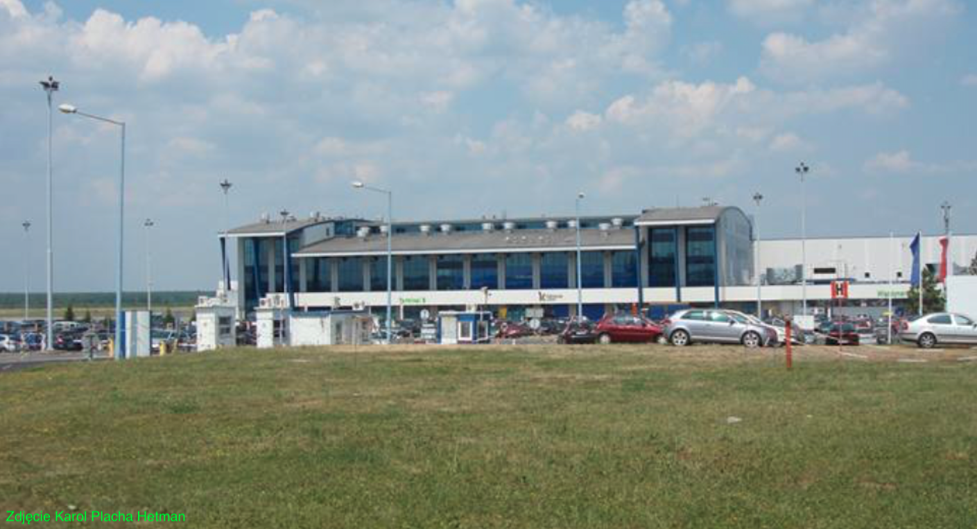
Lotnisko rozwijało się szybko, a jak na Polskie warunki niezwykle dynamicznie. W 2006 roku, przepustowość lotniska wyniosła 1,6 milionów pasażerów. A w 2007 roku, po oddaniu do eksploatacji Terminalu B przepustowość zwiększyła się do 3,5 milionów pasażerów. Port lotniczy w Pyrzowicach był najprężniej rozwijającym się Polskim portem lotniczym. Ma największą liczbę połączeń czarterowych. W okresie 2003 – 2004 udało się zarządowi portu przyciągnąć do Pyrzowic tanie linie lotnicze. W 2007 roku, oddano do użytku Terminal pasażerski B, a w planach był już Terminal C. Prowadzono także intensywne studia na temat zaprojektowania i budowy drugiej drogi startowej RWY, równoległej do istniejącej.
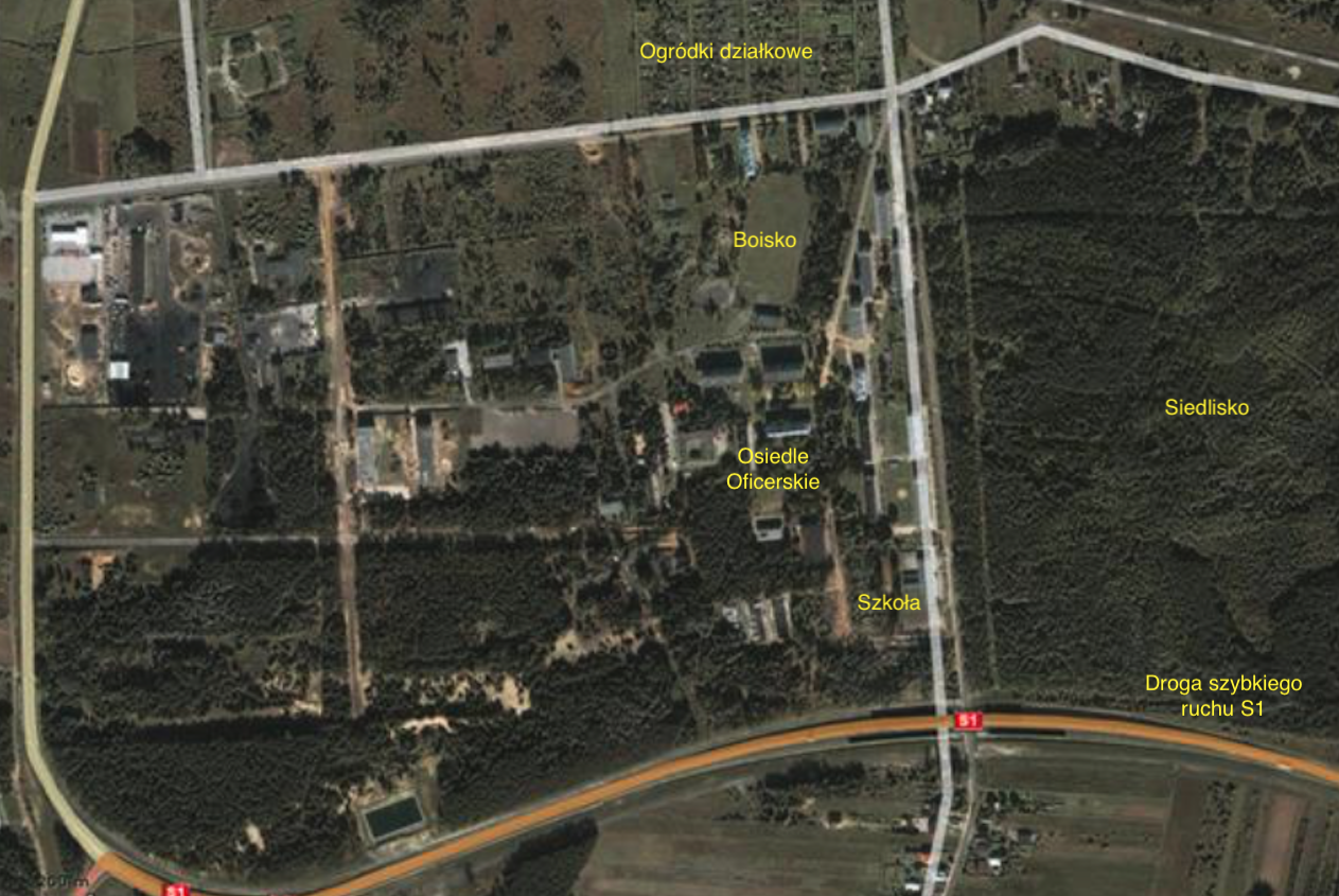
Osiedle oficerskie.
Na południe od Lotniska istnieje osiedle mieszkaniowe zwane kiedyś osiedlem oficerskim. Mieszkali tutaj zawodowi wojskowi wraz z rodzinami. Osiedle składa się z około 20 bloków mieszkalnych i całego zaplecza, ze sklepami i ośrodkami kulturalnymi. Pierwsze bloki mieszkalne powstały z początkiem 50-lat, a ostatnie w 80-latach XX wieku. Bloki są dwu i cztero piętrowe. W 2010 roku, osiedle było zamieszkałe przez cywilów. Populacja to około 1 000 osób. Mieszkańcy stanowią 1/7 całej populacji Gminy.
Infrastruktura Lotniska Mierzęcice Pyrzowice. 2010 rok.
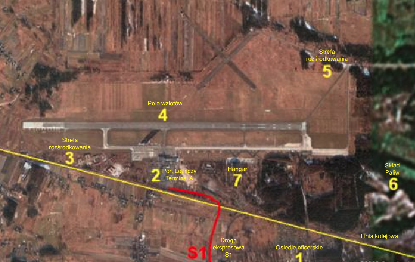
Międzynarodowy Port Lotniczy Katowice w Pyrzowicach. Jedna droga startowa RWY: 09/27, beton 2 800 m x 60 m. Kod ICAO: EPKT. Kod IATA: KTW. Tower: 129,250 MHz. Adres; ul. Wolności 90. 42 – 625 Pyrzowice (Ożarowice). tel.: 0048 32 284 50 90, 0048 32 39 27 200. fax: 0048 32 284 50 53, 0048 32 39 27 376. Górnośląskie Towarzystwo Lotnicze S.A. adres; al. Korfantego 38, 40-161 Katowice. tel: 0048 32 201 06 33, fax: 0048 32 201 06 34. Informacja Lotniskowa: tel. (32) 39 27 385. "LOT": tel. 0 801 703 703 kom. tel. (22) 95 72. Informacja o sprzedaży biletów: tel. (32) 284 50 50. Odprawa bagażowo-biletowa: tel. (32) 284 50 05. Bagaż zagubiony: tel. (32) 284 50 06. Informacja Celna: tel. (32) 358 71 00. Straż Graniczna Komenda Główna: tel. (22) 845 40 71. Informacja Paszportowa: tel. (32) 200 15 47.
Lokalizacja lotniska jest korzystna. Międzynarodowy Port Lotniczy Katowice w Pyrzowicach usytuowany jest w odległości: Katowice 34 km, Bytom 23 km, Chorzów 38 km, Sosnowiec 20 km, Gliwice 40 km, Zabrze 40 km, Częstochowa 60 km, Opole 100 km, Bielsko Biała 100 km, Kraków 97 km, Warszawa 230 km. W rejonie lotniska mieszka około 11 000 000 obywateli Rzeczypospolitej Polskiej. Leży na wysokości 298 m npm i jest najwyżej położonym portem lotniczym w Rzeczypospolitej Polskiej.
Lotnisko słynie w kraju z największej liczby dni w roku, o korzystnych warunkach pogodowych dla lotnictwa, a szczególnie warunków do lądowania. Mitem są informacje, iż z powodu zadymienia na Śląsku ruch lotniczy na lotnisku w XX wieku był utrudniony. Drugim atutem portu jest najdłuższy, a jednocześnie osłonięty (nie na wolnym powietrzu) taras widokowy. Ma długość około 190 m. Uprzedzając fakty, w 2020 roku, w związku z rozbudową terminali, ogólnie dostępny taras widokowy został zlikwidowany.
Lotnisko wyposażono w wysokiej klasy system wspomagający lądowanie ILS. Na system składają się dwa zespoły urządzeń: nadajnik kierunku (Localizer) oraz ścieżki schodzenia (Glide Path). Pokrycie dla odbioru kierunku lądowania wynosiło 30 mil. Standardowo, na wyposażeniu znajdowała się także radiolatarnia DME, służąca do pomiaru odległości.
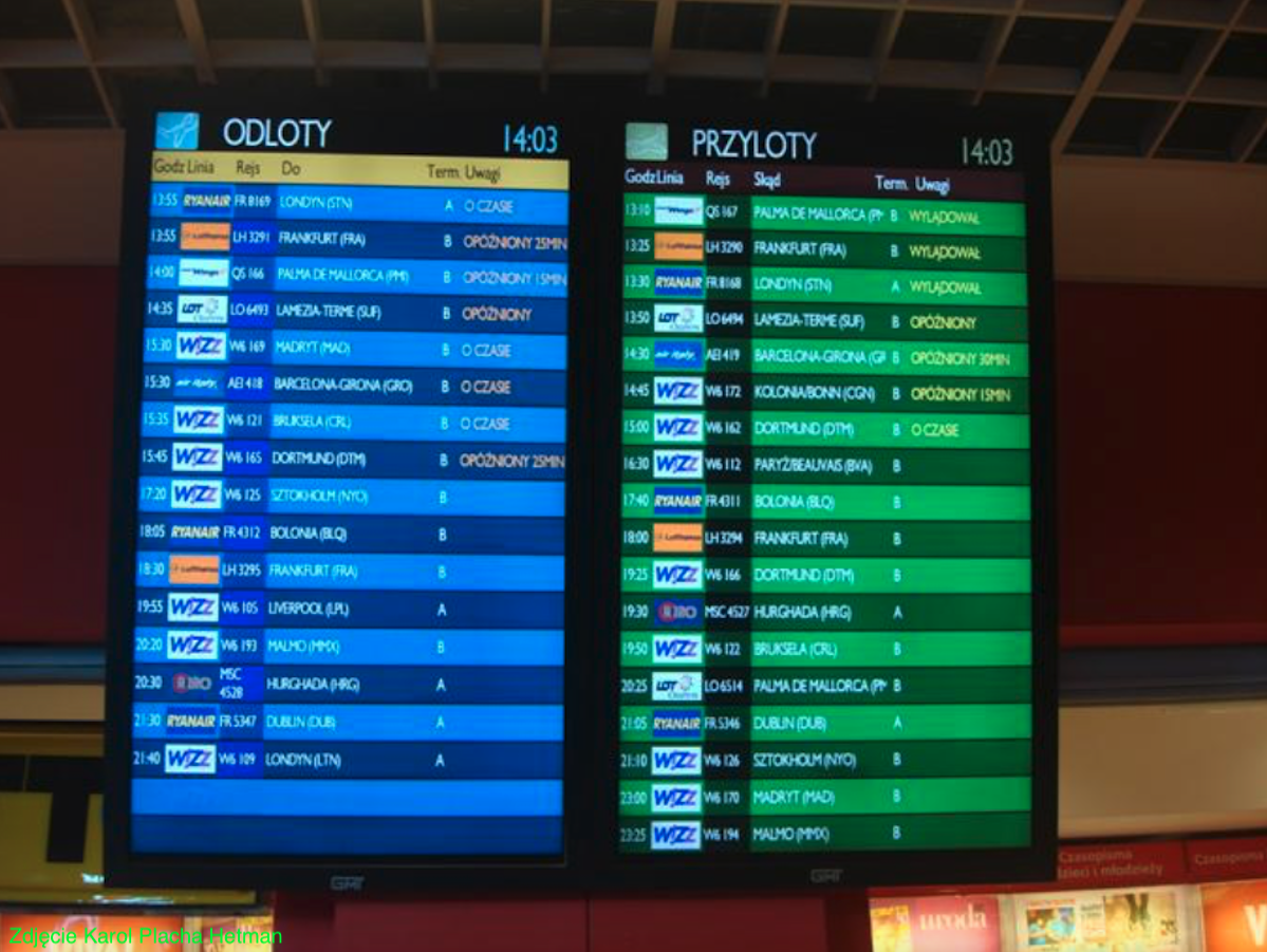
W 2009 roku, linie lotnicze które korzystały z Lotniska Pyrzowice to; LOT Polish Airlines, Euro LOT, Air France, Lufthansa, Wizz Air, Brit Air.
Droga Startowa.
Lotnisko posiadało jedną twardą RWY, o wymiarach 2 800 m x 60 m, na kierunku 09/27. RWY początkowo miał wymiary 1 500 m x 50 m. W 1951 roku, RWY została oddana do użytku po remoncie. Wówczas otrzymała powiększone wymiary; 1 600 m x 60 m, a jednocześnie wykonano pierwsze utwardzone DK. Wydłużanie RWY następowało mniej więcej tak, jak wprowadzano na uzbrojenie kolejne szybsze samoloty myśliwskie. Z końcem 50-lat, RWY wydłużono do 2 000 m. Z końcem 60-lat do 2 400 m. W 2001 roku, RWY osiągnęła 2 800 m. Powierzchnia to 168 000 metrów kwadratowych. Nawierzchnia betonowa.
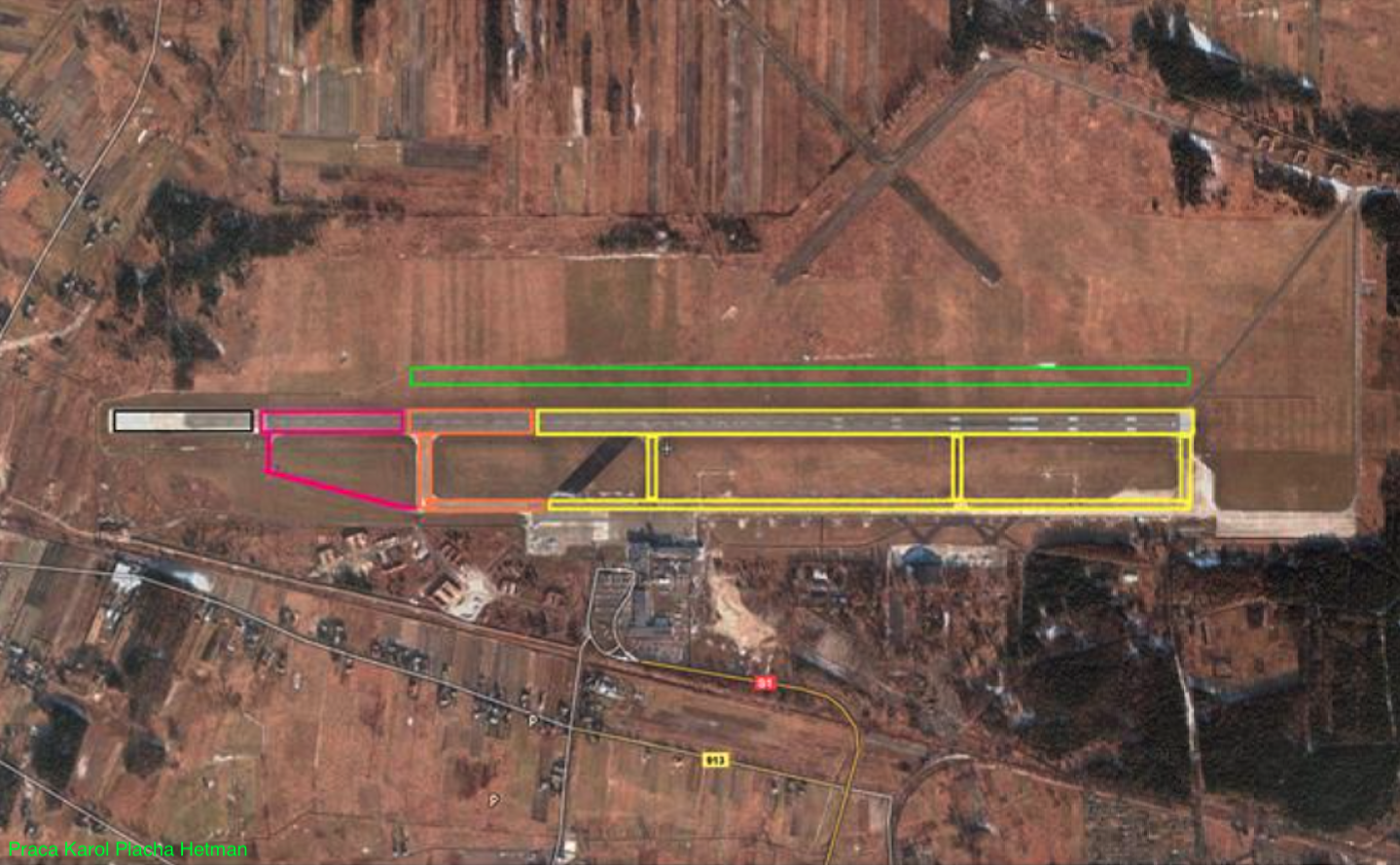
Opis zdjęcia: Kolor żółty – etap około 1951 rok. Kolor pomarańczowy – etap około 1958 rok. Kolor czerwony – etap około 1966 rok. Kolor czarny – etap około 2001 rok. Kolor zielony – awaryjna RWY.
Pisząc o RWY trudno nie wspomnieć, o trwającym od kilku lat procesie modernizacji pola wzlotów, zmierzającego do powstania zupełnie nowej drogi startowej, równoległej do istniejącej. Miałaby ona mieć długość 3 200 m, czyli o 400 m więcej niż obecna. Ale przede wszystkim nowa RWY miała mieć dużo większą nośność, mogąc przyjmować największe samoloty świata. Przypomnijmy, że podbudowa istniejącej drogi była słaba i powstała w czasie drugiej wojny światowej. W 2010 roku, należało sadzić, że inwestycja zostanie zrealizowana.
W dniu 26 listopada 2012 roku, w Katowicach Górnośląskie Towarzystwo Lotnicze, zarządca portu, podpisało w sprawie nowej drogi startowej umowę z firmą Budimex. Kontrakt wyceniono na 121 milionów złotych. Nowa RWY zostanie wybudowany w odległości 195 m na północ od obecnej RWY. Będzie miał wymiary 3 200 m x 60 m. Dokładna szerokość RWY wyniesie 45 m, plus 2 x 7,5 m pobocza. Nawierzchnia to beton asfaltowy. Oprócz tego powstaną nowe DK i drogi techniczne. Planowano zbudowanie czterech szybkich zjazdów. Przebudowie ulegnie system radionawigacyjny, teletechniczny i meteorologiczny. Obecny RWY zmieni się w drogę kołowania. Powierzchnia nowego RWY wraz z układem głównych dróg kołowania; L, N, R i S wyniesie 208 500 m kwadratowych. Rozbudowie ulegnie Płyta Peronowa. Będzie miała powierzchnię 110 000 m2 i pomieści 13 samolotów klasy B 737. Jeśli wszystko pójdzie zgodnie z planem, to obiekt zostanie oddany do użytku we wrześniu 2014 roku. Dzięki budowie nowej RWY Pyrzowice będą mogły obsłużyć nawet największe samoloty, odlatujące z pełnym obciążeniem. Dotychczas taka obsługa wiązała się z ograniczeniami.
Pozostała infrastruktura lotniska wojskowego.
Oprócz RWY lotnisko posiadało główną DK, równoległą do RWY oraz sześć DK łączących z RWY. Łącznie około 3 000 m. Jedna z DK (łącznic) stanowi pozostałość po RWY 04/22 i jest obecnie tak zwanym szybkim zjazdem. Lotnisko posiada dodatkowo jeszcze około 5 000 m dróg kołowania, których szerokość wynosi około 10 m, obecnie (2013 rok) nie wykorzystywanych. Służyły one do kołowania samolotów w rejony rozśrodkowania, na indywidualne stanowiska postoju.
Lotnisko posiada cztery PPS. Pierwsza CPPS zlokalizowana jest naprzeciwko Terminali A i B. Ma wymiary około 450 m x 150 m i blisko 70 000 m kwadratowych. Druga równie duża, umieszczona jest we wschodniej części lotniska. Ma wymiary 350 m x 70 m. W pobliżu umieszczono dwie mniejsze PPS. Druga, trzecia i czwarta PPS jest wykorzystywana do obsługi samolotów transportowych. Lotnisko posiada także PPS zlokalizowaną przed hangarem, która ma wymiary około 300 m x 50 m.
Hangary. Obecnie (2012 rok) na lotnisku zlokalizowany jest tylko jeden hangar. W 2010 roku, poddano go remontowi. Hangar w podstawie ma 80 m x 50 m. Obok niego był zlokalizowany drugi hangar o konstrukcji drewnianej. Z uwagi na zły stan został rozebrany.
Strefy rozśrodkowania samolotów bojowych.
Na Lotnisku Mierzęcice zlokalizowano dwie strefy rozśrodkowania samolotów bojowych. Pierwsza strefa została zlokalizowana w zachodniej części lotniska. Umieszczono w niej 14 stanowisk (stojanek) grupowanych parami. Otoczono je z trzech stron wysokimi wałami ziemnymi. Drugą strefę rozśrodkowania umieszczono w północno-wschodniej części lotniska. Znalazło się tam 30 indywidualnych stanowisk samolotów. Tylko 7 z nich zostało otoczonych z trzech stron wałami ziemnymi. Trzeba zaznaczyć, iż stanowiska położone na wschodzie są umieszczone w gęstym lesie. Środkowe otoczono wałami, w terenie częściowo zalesionym, a zachodnie znajdują się na kompletnie otwartej przestrzeni. Na lotnisku nigdy nie zbudowano schronohangarów. Świadczy to, o stopniowej utracie wiodącej pozycji lotniska w systemie obronnym Polski.
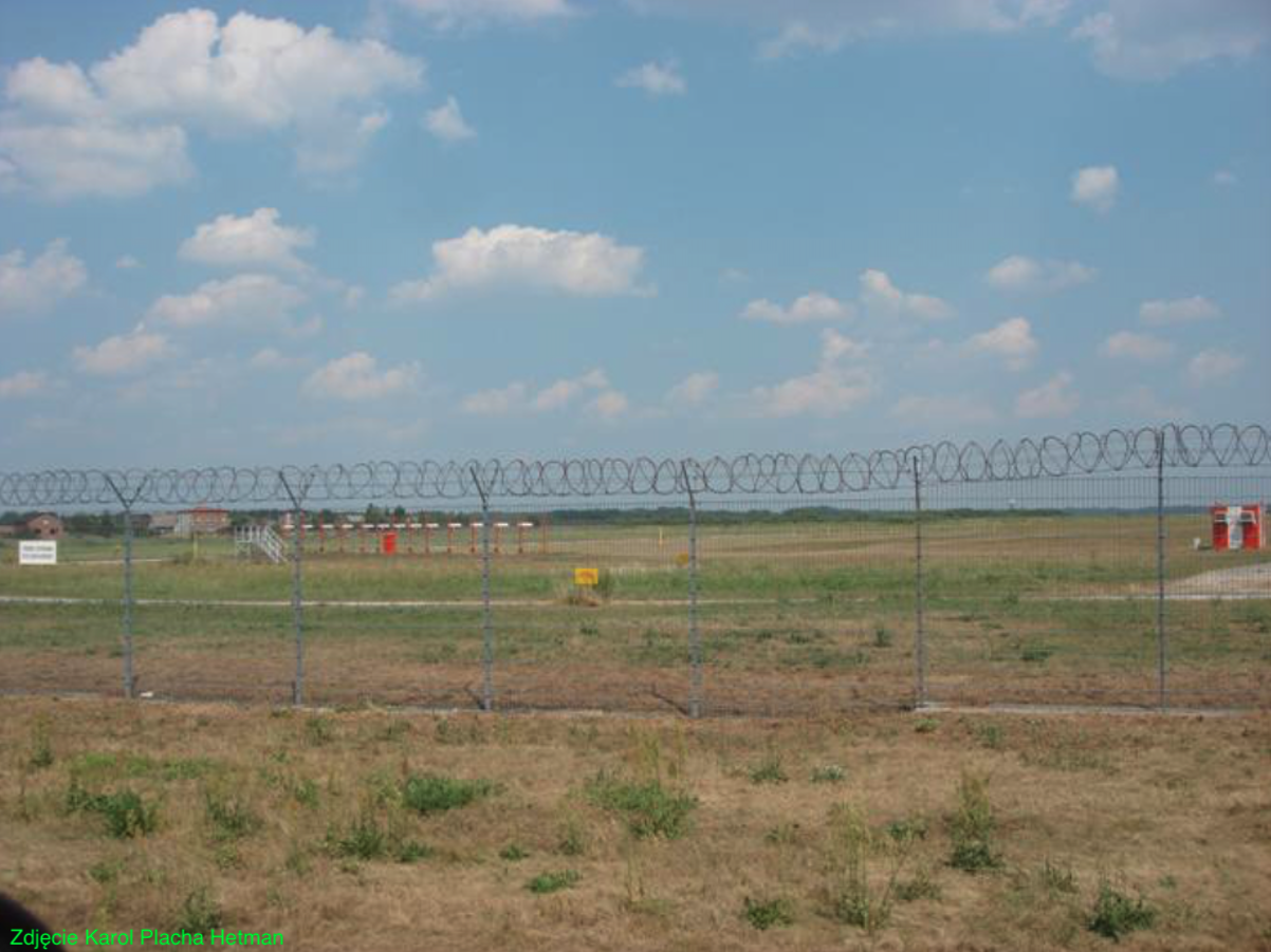
Na terenie Lotniska, dla potrzeb pułku, umieszczono także; wieżę kontroli lotów, strzelnicę samolotową, MPS, bocznice kolejowe. Z tych obiektów eksploatowany obecnie (2010 rok) jest tylko MPS. Paliwo transportowane jest auto-cysternami. Cały teren lotniska jest ogrodzony.
Opracował Karol Placha Hetman