Kraków 2013-01-29
Początki nawigacji.
Wstęp
Nawigacja jest tak stara jak życie na ziemi. Sporo gatunków zwierząt miało już swoje wrodzone zdolności nawigacyjne. Chociażby ptaki, z bocianami na czele. Człowiek nieświadomie zaczął uczyć się nawigacji od momentu wypraw na polowania. Potem były wyprawy wojenne i handlowe. Już w starożytności byli pierwsi podróżnicy, którzy opisywali swoje wyprawy. Określali kierunki przemieszczani się. Zaczęły powstawać pierwsze plany, a po nich mapy. W ich efekcie rozwinęła siękartografia, która połączyła się z chronologią, czyli kalendarzem i czasem.
Poruszanie się lądem nie stanowiło dla człowieka większych problemów. To tych podróży często wykorzystywano rzeki. Liczne charakterystyczne punkty stanowiły i stanową punkty orientacyjne. Wystarczyło tylko zapamiętywać je poruszając się w przód i odnajdywać je poruszając się wstecz. Tak czynili pierwsi myśliwi. Przy okazji tworzyły się ścieżki, które z czasemprzekształcały się w szlaki. Już wówczas nieświadomie określali kierunki świata; tam gdzie wschodzi słońce – wschód, tam gdzie zachodzi słońce – zachód, połowa dnia, słońce najwyżej – południe, połowa nocy – północ. Kierunki świata określane na podstawie słońca stawały się istotne w chwili zagubienia się lub przemieszczania się po terenach pustynnych, sawannowych lub niezróżnicowanych (wieczna zmarzlina). Każdy, kto zapuszczał się bardzo daleko od domu był uważany zaodważnego. Odległości dalekich wypraw liczyli ilością dni potrzebnych do pokonania danej trasy. Te wyprawy wzbogacały społeczności o kolejne informacje, a w zasadzie o wiedzę.
Początki żeglugi.
Człowiek stosunkowo szybko opanował nawigowanie po lądzie, często wykorzystując rzeki. Dużo dłużej trwało opanowanie nawigowania na akwenach. O ile człowiek stosunkowo szybko nauczył się budować łodzie i z nich korzystać, to długo trwało zanim wypłynął daleko w morze. Poprzednie pokolenia dobrze wykorzystywały rzeki i charakterystyczne punkty orientacyjne przy brzegach. Dlatego rozwinęła się żegluga przybrzeżna. W starożytności ludzie nie oddalali się daleko od brzegów, chcąc cały czas mieć na widoku charakterystyczne punkty na lądzie. A gdy ich nie było, to ci, którzy byli na brzegu palili ogniska, które miały dawać jak najwięcej dymu, który był punktem orientacyjnym. Po Morzu Czerwonym łodzie pływały znacznie wcześniej, nim wzniesiono piramidy. Większe łodzie (statki) na Morzu Śródziemnym i w Zatoce Perskiej pojawiły się około 7 000 lat p.n.e. Przeważnie były to statki rybackie, lecz niektóre już służyły handlowi, a czasami ich załogi trudniły się rozbojem.
Morza, na których pojawiły się te pierwsze okręty, były morzami śródlądowymi, gdzie wiatry wieją zmiennie i gdzie często całymi dniami trwa śmiertelna cisza. Dlatego rozwinęły się statki, których napędem były wiosła, które poruszali wioślarze. Często byli oni niewolnikami, jeńcami, więźniami, czyli galernikami. Takie statki w chwili zbliżania się złej pogody natychmiast płynęły do najbliższego portu.
Lecz poruszanie się na otwartych akwenach wodnych było sporym wyzwaniem. Najwięcej doświadczenia ludzkość uzyskała w basenie Morza Śródziemnego. Płynąc wzdłuż brzegu docierano do miejsc po przeciwnej stronie. Opisywano szlaki i punkty orientacyjne. Zdobytą wiedzę przekazywano z pokolenia na pokolenie. Z czasem obierano kursy w poprzek morza, kierując się stronami świata, które wyznaczano na podstawie słońca. Bodźcem do rozwoju żeglugi, a przy niej nawigacji, był transport morski. Bo zorientowano się, że transport statkami wyposażonymi w żagle był tańszy i szybszy od transportu lądowego. A przede wszystkim wymagał angażowania mniejszej liczby ludzi i całkowicie wyeliminował zwierzęta pociągowe. Już tutaj mamy do czynienia z zależnością koszt-efekt. Owszem, angażowano mniejszą ilość ludzi, ale oni musieli posiadać znacznie większą wiedzę, właśnie w temacie nawigacji. Kolejnym etapem było opanowanie żeglugi w ciągu nocy.
Kreteńczycy.
Zgodnie z poznaną historią, Kreteńczycy byli pierwszą społecznością, która opanowała w nowoczesny sposób żeglugęmorską. Panowanie na morzu należało do Krety na przełomie III i II tysiąclecia p.n.e.. Mniej więcej do VII wieku p.n.e., Kreta była wówczas centrum wymiany handlowej na Morzu Śródziemnym. Lecz z uwagi na silniejsze ludy semickie rozwój imperium Kreteńskiego został zahamowany. Do dnia dzisiejszego Kreteńczycy podkreślają swoją odrębność od innych narodów, nawet Greckiego, w państwie, w którego są w granicach.
Bezpośrednimi spadkobiercami Kreteńczyków stali się Achajowie z Grecji Mykeńskiej, których ekspansja morska rozpoczęła się w XV w. p.n.e., gdy załamała się potęga Krety. Statki pod egipską banderą penetrowały wówczas głównie wody Morza Czerwonego.
Fenicjanie (Kananejczycy).
Bardziej znani są Fenicjanie. Wraz z upadkiem kultury mykeńskiej pod koniec II tysiąclecia p.n.e., na morzu rozpoczął się okres panowania Fenicjan, którzy do dziś noszą miano najlepszych żeglarzy starożytności. Znana była powszechnie starożytnym ich odwaga i przedsiębiorczość, które skłaniały ich do żeglugi po otwartym oceanie i odkrywania nowych lądów. Przodowali oni w budownictwie okrętowym, dzięki czemu mogli się przemieszczać po całym basenie Morza Śródziemnego. Fenicjanie, jako lud semicki osiedlił się na nadbrzeżnych terenach dzisiejszego Libanu i Syrii, od około III tysiąclecia p.n.e.. Fenicjanie nazywali siebie Kananejczykami. Za nazwą tą przemawia też określenie w języku hebrajskim „kena’ani”, które przyjęło wtórne znaczenie jako „kupiec”. Ponieważ mieszkali w miastach-państwach, między innymi w Sydonie, stąd w Starym Testamencie często występują pod nazwą Sydończyków. Fenicjanie byli dobrymi żeglarzami, ale dopiero po upadku kreteńskiej potęgi laur pierwszeństwa przeszedł na Fenicjan (po XII w. p.n.e.). Fenicjanom przyznaje się odkrycie i wprowadzenie do użytku wielu wynalazków. Na przykład; wynalazek pieniądza, obróbka metali kolorowych, czy obróbka szkła. Jednak wydaje się, że głównym osiągnięciem Fenicjan jest rozpropagowanie tych wynalazków. Trudniąc się handel przewozili srebro, cynę, ołów, miedź i złoto. Fenicjanom przyznaje się wynalazek pisma sylabowego, które pozwoliło im na utrwalanie informacji w tej postaci, a dodatkowo rozpropagowali to pismo. Fenicjanie najpierw dotarli na Cypr, a później na Sycylię, Maltę, Sardynię, Korsykę, aż po Afrykę Północną (Kartagina) i Gadessa (dziś Kadyks) w Hiszpanii. Później Fenicjanie, a właściwie Kartagińczycy, opłynęli Afrykę, odkryli Wyspy Kanaryjskie i Maderę, najprawdopodobniej również Azory i WyspyZielonego Przylądka. Istnieją przypuszczenia, że Kartagińczycy dotarli do wybrzeży Brazylii. Jeśli tak, to musieli znać zjawisko pasatu północno-wschodniego, który przez znaczną część roku wieje w kierunku południowo-zachodnim, czyli wkierunku wybrzeży brazylijskich. Również dzięki temu wiatrowi Krzysztof Kolumb dotarł z Wysp Kanaryjskich do wysp środkowoamerykańskich.
Grecy, Fenicjanie, a następnie Kartagińczycy byli pierwszymi, którzy nawigowali w nocy. Nawigowanie w nocy oznaczało, że mogli wyruszać w wyprawy trwające kilka dni, a potem nawet kilka tygodni. Oznaczało to również, iż potrafili na podstawie położenia słońca i gwiazd określać swoje położenie, a przede wszystkim wyznaczać kierunki świata. W ten sposób stworzyli nawigację, którą określamy jako nawigacja zliczeniowa. Oni pierwsi zbierali informacje o stałych wiatrach i prądach morskich. O zjawiskach pogodowych niebezpiecznych i przyjaznych. Mając własne pismo, byli w stanie zapisywać te informacje i przekazywać następnym pokoleniom.
Pierwsi żeglarze cumowali swoje łodzie w naturalnych zakolach rzek lub na mieliznach. Łodzie były lekkie, więc zwykle wyciągano je na brzeg. W miarę zwiększania się wielkości jednostek i odległości, na jakie je wysyłano, a także wymagań im stawianych, zaczęto naturalne przystanie zagospodarowywać do pełnienia funkcji bezpieczniejszych portów. Tak powstawały pierwsze porty, których wielkość zależała od ilości obsługiwanych jednostek. Dla większych jednostek organizowano kotwicowiska umieszczone w zatokach. W miarę rozwoju żeglugi te pierwsze porty rozbudowywały się. Budowano baseny portowe, wznoszono budynki administracji portowej, arsenały, magazyny, latarnie morskie, mury warowne w celu ochrony od strony lądu. Fenicjanie byli pierwszymi wielkimi morskimi architektami świata starożytnego. Założone, jako szereg punktów postojowych przystanie, z czasem pod ich rządami stawały się świetnie prosperującymi koloniami. Warto zaznaczyć, że Fenicjanie na swoje siedziby wybierali miejsca z reguły podobne do ich ojczystych terenów.
Rzymianie.
Z czasem Kartagina rywalizująca z Rzymianami utraciła palmę pierwszeństwa. Podejrzewa się, że Rzymianie przejęli całą wiedzę Kartagińczyków o żegludze i nawigacji i dalej ją rozwinęli. Podaje się, iż Rzymianom zawdzięczamy pierwsze księgi opisujące znane szlaki morskie. Opisali w nich punkty orientacyjne, kotwicowiska, kolejne porty, zatoki i strefy niebezpieczne. Podawali orientacyjne odległości między nimi. Księgi te nazywamy Periplus (gr. περίπλους, w tłumaczeniu dosłownym żeglować wokół). Jednak pierwszy znany taki rękopis powstał około IV wieku p.n.e. Nosi nazwę „Periplus Pseudo-Scylaxa” i opisuje wybrzeże Półwyspu Iberyjskiego i Apenińskiego, został napisany przez Fenicjan. W I wieku p.n.e., powstał dokument „Periplus Maris Erythraei”, który opisuje wybrzeże Morza Czerwonego i Oceanu Indyjskiego, a został napisanyprzez greckiego kupca. Lecz faktem jest, że Rzymianie opracowali tych ksiąg dużo, a na ich bazie powstały dzisiejsze locje dla akwenów całego świata.
Pomijając Morze Czerwone, które niczym szczególnym się nie wyróżnia, to pierwszym morze opanowanym całkowicie przez człowieka było Morze Śródziemne. Dokonali tego Rzymianie, którzy już w I wieku p.n.e. potrafili po nim żeglować z portu początkowego do docelowego bez zawijania do portów pośrednich. Bez wątpienia przyczyniły się do tego księgi Periplus, a także wolny, ale systematyczny rozwój pomocy nawigacyjnych. Opanowano Morze Czarne. Stopniowo żeglarze zapuszczali się na Morze Północne i Bałtyckie.
Log.
Pierwszą taką pomocą nawigacyjną był Log (od ang. log, kloc, kłoda, polano). Przyrząd Log określa prędkość poruszania się jednostki pływającej, a przez to przebytą drogę. Składał się on z drewnianego klocka z przyczepioną do niego linką, na której w jednakowych odległościach były zawiązane węzły. Klocek wyrzucano za burtę i liczono przesuwające się węzły od klocka, który działając jak hamulec oddalał się, w jednostce czasu. Ilość policzonych węzłów była jednostką prędkości. Czas mierzono przy pomocy klepsydry. Dlatego do dnia dzisiejszego prędkość jednostek pływających, a także latających, podaje się w węzłach (knot), czyli milach morskich na godzinę.
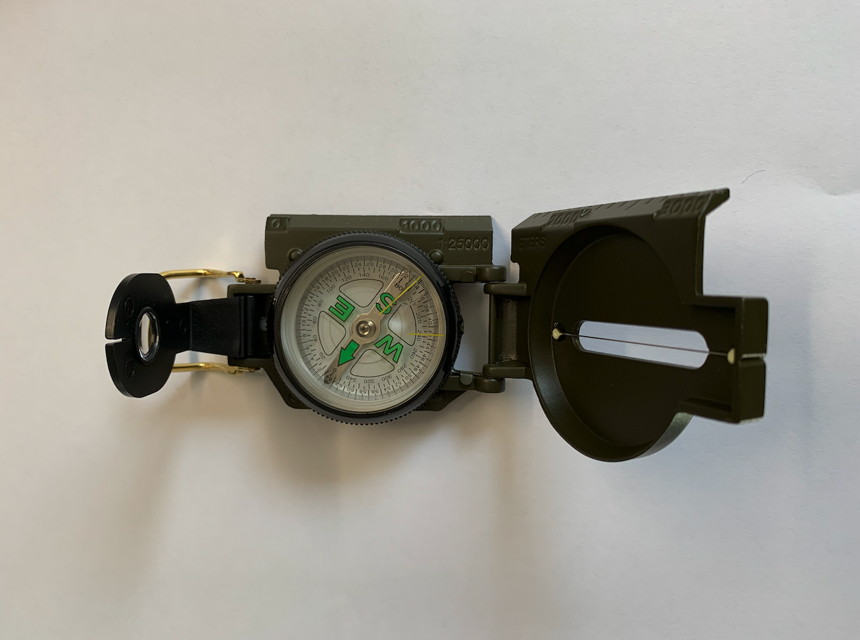
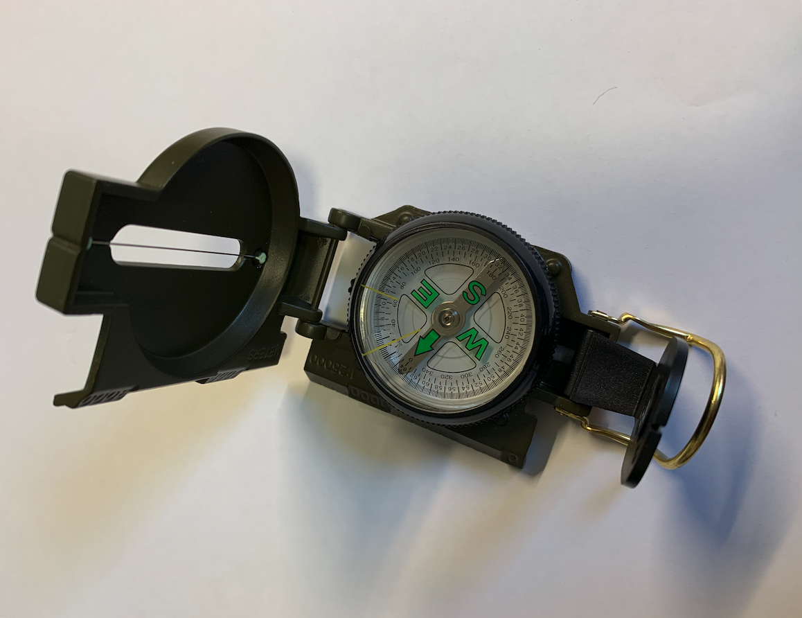
Busola i kompas.
Magnetyt to minerał z gromady tlenków, zaliczany do grupy spineli (żelazowych). Należy do minerałów bardzo pospolitych i wyjątkowo szeroko rozpowszechnionych. Własności fizyczne kawałków magnetytu odkryto stosunkowo wcześnie. Jedną z istotnych jego cech jest ustawianie się według linii sił ziemskiego pola magnetycznego. Figurki wykonane z magnetytu zawieszone na nitce zawsze wskazywały północ. Takie figurki wykonywano w Chinach. Przypuszcza się, że z Chin trafiły do Europy. Lecz kamień magnetis był już znany starożytnym Grekom. Nazwa pochodzi od dawnego greckiego miasta Magnesia (obecnie Manisa), dziś na terenie Turcji. Termin magnes wprowadzono w 1845 roku (W. Haidinger). Więc możliwe, że odkrycia te były niezależnie.
Magnetyt oprawiano w drewno i kładziono na wodę. Taki przyrząd ustawiał się w kierunku północnym. W XIII wieku (około1200 roku) włoscy żeglarze zastąpili pływającą „igłę” nowym przyrządem. Było to pudełko z drewna bukowego z zamkniętą wewnątrz igłą. Stąd pochodzi nazwa busola. Buk po łacinie to „buxus”. Nieco później pod igłą na dnie pudełka umieszczonopodziałkę w stopniach. Pozwoliło to nie tylko wyznaczać kierunek północny, ale także i kierunki pośrednie. Taki przyrząd nazwano kompasem (od włoskiego „compaso” – podziałka). W topografii przyjęto rozumieć kompas, jako pudełko z podziałką w stopniach, zawierające zawieszoną igłę magnetyczną. Natomiast busola to pudełko z igłą magnetyczną i podziałką oraz wyposażone w urządzenie służące do celowania, pomagające wyznaczyć azymut. Może to być na przykład ruchomy pierścień z muszką i szczerbinką. Czasami w pokrywie busoli umieszczane jest lusterko, które pomaga w jednoczesnym celowaniu i kontrolowaniu wskazań igły magnetycznej.
Mapy żeglarskie. Mapy nawigacyjne.
Pierwsze mapy żeglarskie powszechnego użycia pojawiły się w czasach Rzymskich. Nazywane były mapami rumbowymi. Ich podstawą były kierunki świata rozrysowane na róży wiatrów. Róża wiatrów, a praktycznie okrąg wokół niej, została podzielona na 32 części, zwane rumbami. Nie znano wówczas stopni, czyli podziału okręgu na 360 stopni. Prostsze mapy miały podział na 8 lub 16 rumbów.
32 rumby wynikają z następujące podziału; Okrąg dzielimy na 4 ćwiartki. Każda ćwiartka jest na połowę, a każdą połowa na kolejne dwie części, a każdą z tych części na kolejne połowy i na tym koniec. Łącznie powstały 32 jednakowe części. Nie dzielono dalej bo to było niepotrzebne i zamazywało Różę wiatrów.
W XII wieku (Średniowiecze) pojawiają się dokładne mapy żeglarskie zwane mapami kompasowymi. Przyczynkiem do ich powstania było pojawienie się busoli, która była dużo prostsza do użycia niż igła magnetyczna oprawiona w drewno.
Mapy kompasowe, nazwane później nawigacyjnymi, stanowią efekt doświadczeń wielu pokoleń, zdobytych w czasie licznych podróży morskich po Morzu Śródziemnym i przyległych wodach Atlantyku. Żeglarskie mapy kompasowe, sporządzane zwykle dla potrzeb żeglugi morskiej, pierwotnie nie posiadały siatki kartograficznej złożonej z południków i równoleżników. Charakterystyczną ich cechą były linie kierunkowe rozchodzące się promieniście (zgodnie z Różą wiatrów) od ważnych punktów, którymi były duże miasta i duże porty. Linie te tworzyły charakterystyczną siatkę. Linia brzegowa, a przez to kształt lądów był przedstawiony stosunkowo wiernie. Płynąc zgodnie z tą siatką docierano do celu podróży bez potrzeby żeglowania wzdłuż brzegów.
Na typowe mapy nawigacyjne należało poczekać do wielkich odkryć geograficznych oraz rozpowszechnienia się papieru i druku. A także powstania znanej nam współcześnie siatki geograficznej.
Laska Jakuba.
Levi ben Gerson (matematyk i astronom) w 1321 roku, stworzył przyrząd nazwany Laska Jakuba (Jakuba ze StaregoTestamentu), który służy do pomiaru wysokości w geodezji i astronomii, a w konsekwencji był używany w żeglarstwie. Laska Jakuba jest to przyrząd nawigacyjny w postaci prostej listwy z ruchomą poprzeczką i skalą kątową, stosowany do mierzenia kątowej wysokości ciał niebieskich nad horyzontem. Patrząc wzdłuż laski należało przesuwać poprzeczkę do momentu, aż jej dolny koniec wskazał linię horyzontu, a górny gwiazdę stałą. Miejsce poprzeczki wskazywało na skali wysokość kątową. Przyrząd został wyparty w XVII wieku przez Sekstant.
Wielkie odkrycia geograficzne.
Z takim bagażem wiedzy rozpoczęła się era wielkich odkryć geograficznych. Wielkie odkrycia geograficzne to popularne określenie odkryć geograficznych dokonanych przez europejskich żeglarzy w okresie 1450 – 1650 roku. Do najważniejszychodkryć należą; Opłynięcie Przylądka Dobrej Nadziei przez Diasa (1488 roku). Dotarcie do Ameryki przez Krzysztofa Kolumba (1492 rok). Podróż Vasco da Gamy do Indii (1498 rok). Podróż dookoła świata Ferdynanda Magellana (1519r.-1522r.). Erę wielkich odkryć kończy odkrycie Australii.
W ich następstwie odkryć doszło do dalszego rozwoju podróży, podejmowanych w ramach rywalizacji portugalsko-hiszpańskiej, z udziałem Francji, Anglii i Holandii. W okresie wielkich odkryć nastąpiło czterokrotne rozszerzenie horyzontuprzestrzennego oraz całkowita zmiana dotychczasowych wyobrażeń o liczbie, rozmiarach, rozmieszczeniu lądów i oceanów na kuli ziemskiej. Także o wymiarach Ziemi, większych od przyjmowanych od czasów Klaudiusza Ptolemeusza. W ślad zaodkryciami nastąpił rozwój kartografii. Całkowitej zmianie uległ kartograficzny obraz Ziemi. W wydanych w XVI w. we Flandrii atlasach (Ortelius, Merkator) zupełnie zrewidowano mapy Ptolemeusza. Przewrotem w kartografii było wydanie wiernokątnej mapy świata Gerarda Merkatora. W 1525 roku, Philipp Apian podał metodę wyznaczania długości geograficznej za pomocą odległości kątowej gwiazd stałych od Księżyca, co uważa się za początek nowożytnych pomiarów geograficznych. Ogłoszenie teorii heliocentrycznej budowy układu planetarnego Mikołaja Kopernika oznaczało zmianę poglądów na miejsce Ziemi w kosmosie i zerwanie z nauką Ptolemeusza. Nastąpił początek geografii nowożytnej.
Co ważne, te odkrycia nie spowodowały upadku religijnego spojrzenia na świat, a wręcz przeciwnie utrwaliły to spojrzenie. Wyobrażenia Ziemi snute na podstawie Biblii uległy radykalnej zmianie, lecz co istotne nie podważyły ani jednej joty w niej zawartej. Samej geografii nadal brakowało podstaw teoretycznych. Ograniczała się do zbierania faktów, za czym nie nadążał rozwój wiedzy o zjawiskach fizycznych. Cele poznawcze schodziły na dalszy plan. Wielu okryć dokonywano przypadkowo. Pamiętajmy, że głównym motorem tych podróży była chęć bogacenia się (nowa droga do Indii). Aby przywieść jeszcze więcej towarów, tańszym transportem morskim i wzbogacić się. Aby założyć nowe kolonie i praktycznie okradać tubylców. Wielkie odkrycia geograficzne pchnęły rozwój cywilizacji do przodu, jednocześnie zniewoliły nowe rejony świata. Rozpoczął się okres wielkiej kolonizacji, w której przodowali początkowo Portugalczycy i Hiszpanie, później dołączyli do Holendrzy, Anglicy i Francuzi. Dotychczasowe Średniowieczne potęgi handlowe, takie jak miasta włoskie czy hanzeatyckie, zaczęły tracić naznaczeniu, a zyskiwały ośrodki takie jak Kadyks, Sewilla, Lizbona, Antwerpia. Był to początek nieodwracalnych zmian historycznych, których efekty widoczne są do chwili obecnej.
Wielkie odkrycia geograficzne potwierdziły empirycznie, że Ziemia jest kształtem zbliżona do kuli. Jednym z efektów był niezwykły rozwój kartografii. Pojawiły się nowe mapy i atlasy.
Holenderski geograf Gerhard Kremer (zwany Gerhardem Mercatorem) opracował sposób przeniesienia powierzchni Ziemina wnętrze cylindra, który po rozłożeniu stał się płaskim arkuszem mapy. Dzięki takiemu odwzorowaniu zarówno południki i równoleżniki, jak i linia stałego kursu (loksodroma), są liniami prostymi. Do dziś takie odzwierciedlenie jest często stosowane w mapach morskich i mapach poglądowych. Choć współczesne mapy lotnicze są wykonywane przez rzutowanie na wewnętrzną powierzchnie stożka.
Astrolabium.
Kiedy na początku XVI wieku Magellan wyruszał w swoją ostatnią podróż, Tycho Brahe skonstruował astrolabium, dla nawigatorów bardziej przydatne od Laski Jakuba.
Astrolabium znane było przypuszczalnie już w II wieku przed nasza erą. Podstawową częścią astrolabium była mosiężna okrągła płyta, na której wyryto linie wysokości ciała niebieskiego nad horyzontem, linie azymutu i koła godzinne. Przez środek płyty przechodziła linia oznaczająca północny biegun nieba. Tak, więc astrolabium odwzorowuje sferę niebieską na powierzchni płaskiej. Jest to swego rodzaju astronomiczny kalkulator, wykorzystywany na przykład do określania godziny wschodu czy zachodu Słońca, albo innej gwiazdy, do konwertowania współrzędnych gwiazd z jednego systemu na inny (poziomego, równikowego, ekliptycznego), albo do określania azymutu, wysokości, rektascensji i odchylenia gwiazd. Kiedy instrument wisiał spokojnie, zero skali pokrywało się z horyzontem. Należało tylko wycelować strzałkę w żądane ciało niebieskie i odczytać kąt. Prawdopodobnie w VIII wieku astrolabia do żeglugi pierwsi używali Arabowie. Astrolabium używałMikołaj Kopernik. W okresie wielkich odkryć geograficznych astrolabia zostały udoskonalone w kierunku określenia położenia obserwatora, a więc korzystne dla nawigacji. W XVIII wieku astrolabium przekształciło się w sekstant, powszechnie znany,jako przyrząd nawigacyjny. Astrolabia są budowane do czasów obecnych. Niestety oprócz funkcji ozdobnych są wykorzystywane we wróżbiarstwie.
Klepsydra i chronometr.
W nawigacji okazało się, że wiedza, co do dokładnego czasu jest niezwykle istotna. Z różnych sposobów pomiarów czasów; słoneczny, świecowy, do żeglarstwa trafił zegar wodny zwany klepsydrą, zamieniony później na klepsydrę piaskową. Konstrukcja znana była już na 1500 lat p.n.e. Klepsydra składa się z dwóch, zazwyczaj szklanych baniek, z czego jednaznajduje się dokładnie nad drugą, połączonych rurką przepuszczającą określoną ilość wody lub piasku w określonym czasie. Znane są klepsydry odmierzające od kilkudziesięciu sekund do doby. Problem jednak w tym, że klepsydra mierzy tylko jedną jednostkę czasu, na przykład przysłowiową godzinę. To nie wiemy, kiedy minęło 15 minut. W XVIII wieku, zbudowano pierwsze chronometry, które wyparły niedokładne klepsydry. Dzięki chronometrowi także zwiększyła się precyzja nawigacji. Pierwszy chronometr zbudował John Harrison w 1761 roku, angielski cieśla, zegarmistrz i samouk. Ten chronometr możnabyło użyć na statkach, Umożliwiło to rozwiązanie problemu określania długości geograficznej. Dzięki swej konstrukcji Harrison zdobył nagrodę parlamentu brytyjskiego w wysokości 20 000 funtów za rozwiązanie tego problemu.
Sekstant.
Sekstant jest przyrządem nawigacyjnym używanym do chwili obecnej. Jest optycznym przyrządem nawigacyjnym. Jest także nazywany kątomierzem lusterkowym. Podstawową częścią przyrządu jest wycinek jednej szóstej koła. Stąd nazwa przyrządu. Najczęstszym zastosowaniem sekstantu jest określenie astronomicznej pozycji obserwowanej na podstawie pomiaru wysokości Słońca z kulminacji – to jest o godzinie 12:00 w południe czasu słonecznego, astronomicznej linii pozycyjnej na podstawie pomiaru wysokości Słońca i czasu (UTC) pomiaru lub określenie pozycji na podstawie pomiarów wysokości gwiazd rano i wieczorem – na przykład określenie szerokości geograficznej z pomiaru wysokości Gwiazdy Polarnej.
Pomiar za pomocą sekstantu polega na wycelowaniu lunetki na horyzont i obracaniu ruchomym ramieniem (alidadą) do momentu, kiedy obraz obserwowanego ciała, odbity w dwu zwierciadłach (ruchomym i nieruchomym podzielonym na połowy: przezroczystą i odbijającą), pokryje się z horyzontem widzianym przez przezroczystą część zwierciadła. Kąt odczytuje się na skali wygrawerowanej na limbusie przy pomocy noniusza lub śruby mikrometrycznej. Rzeczywista wysokość jest dwukrotnie większa od kąta przesunięcia alidady, dlatego – aby uniknąć konieczności mnożenia wyniku przez dwa – podziałka jestdwukrotnie zagęszczona. Tym samym zakres pomiarowy sekstantu wynosi 2 × 1/6 kąta pełnego, czyli 120 stopni.
Pomiarów dokonuje się z dokładnością do 0,1 minuty kątowej. W astronawigacji pozwalałoby to teoretycznie na oznaczenie położenia statku z dokładnością do 0,1 mili morskiej czyli 185 metrów. W praktyce, ze względu na szereg czynników wpływających na dokładność pomiaru, ostateczna dokładność jest kilkanaście razy gorsza. Sekstant, podobnie jak i cała astronawigacja, istnieje do dziś w prawie niezmienionej formie. Opracowywano nowe, doskonalsze tablice astronomiczne, pojawiały się nowe metody obliczeniowe, ale zasada wyznaczania pozycji obserwowanej pozostawała ta sama.
Żyroskop.
Jeszcze w tym rozdziale omówimy żyroskop, który nie jest bardzo dawnym przyrządem, ale pomógł w opracowaniu lepszych przyrządów nawigacyjnych.
Żyroskop swoją historię zaczął od dziecięcej zabawki zwanej bąkiem. Żyroskop jest to urządzenie wynalezione przez francuskiego fizyka Jeana Foucaulta w 1852 roku, i służy do pomiaru, a także utrzymywania położenia kątowego. Działa ono w oparciu o zasadę zachowania momentu pędu. W centralnym miejscu znajduje się stosunkowo ciężki krążek, który jest zawieszony w podwójnej ramce, czyli przegubie Cardana. Krążek raz wprawiony w szybki ruch obrotowy zachowuje swoje początkowe położenie osi obrotu, z małymi ruchami precesyjnymi, które nie są zależne od położenia ramki. Drobne ruchy precesyjne są uwzględniane podczas obliczania kierunku ruchu lub są eliminowane przez tłumienie. Krążek w ramce musi mieć dużą prędkość obrotową, a także być dobrze łożyskowany. W tym celu można użyć łożysk olejowych lub użyć sprężonego powietrza. Można także użyć pola magnetycznego w próżni. Tak skonstruowany żyroskop po nadaniu ruchu krążkowi np.: 24 tysięcy obrotów na minutę wskazuje stały kierunek w przestrzeni z błędem nie większym niż 1° na 14 miesięcy działania w naszym przypadku. Aktualnie stosowane są dokładne żyroskopy laserowe.
W oparciu o żyroskop zbudowano żyro-kompas. Potem były pierwsze autopiloty i bezwładnościowe układy nawigacyjne.
Nawigacja zliczeniowa.
Nawigacja zaliczeniowa w historii ludzkości bardzo się zmieniła i udoskonaliła, choć jest mniej dokładna od astro-nawigacji. Jednak umożliwia określenie pozycji przy złej pogodzie. W XIX wieku, drukowano już bardzo dokładne mapy i atlasy. Zawierały już one stałe prądy morskie i typowe wiatry w danym rejonie. Obecnie nawigacja zliczeniowa jest nadal stosowana, a to za sprawą żyroskopu.
Opracował Karol Placha Hetman