Inowrocław 2012-06-23
Lotnisko w Inowrocławiu. Latkowo.
Współrzędne geograficzne: 52.827N 18.325E. Elewacja 77 m.
Historia Inowrocławia.
Inowrocław to jeden z ośrodków Staropolskich Kujaw. Czasami nazywany Miastem na soli. Urodzajne ziemie sprzyjały rozwoju osadnictwa, wzmiankowanego już na 3 000 lat przed nasza erą. Ponadto osada leżała na Bursztynowym Szlaku. Z dnia 20.01.1185 roku, pochodzi pierwsza wzmianka źródłowa, o targu książęcym „in Novo Wladislaw”. Targ znajdował się w pobliżu kościoła Najświętszej Maryi Panny. Osada musiała się prężnie rozwijać, bo już w XII wieku, postawiono tu murowany kościół. Od 1230 roku, Miasto stało się siedziba księcia kujaw Kazimierza I. Miasto otoczono murami, które chroniły zamek książęcy, klasztor i kościół franciszkański, ratusz, warzelnie i starą część osady. Prawa miejskie Inowrocław uzyskał około 1238 roku. W okresie 1466 – 1772, Inowrocław był stolicą Województwa Inowrocławskiego. Miasto rozwijało się systematycznie przez pięć wieków. To w Inowrocławiu toczyły się rozmowy z krzyżakami. Z Inowrocławia pochodzili Królowie Polski; Władysław I Łokietek i Kazimierz Wielki. Początek schyłku Miasta nastąpił od potopu szwedzkiego, w XVII wieku. Szwedzi przyczynili się do kilkukrotnego wybuchu zarazy w Mieście. Największe spustoszenie przyniosła długotrwała wojna północna (1700 – 1721). Ubogie już wówczas Miasto zrujnowali wojska szwedzkie i moskale. Wszystkie próby ożywienia Miasta kończyły się niepowodzeniem. Miasto stopniowo przejmowała mniejszość germańska. W 1772 roku, Miasto znalazło się w zaborze zarazy pruskiej. Od 1836 roku, burmistrzami miasta mogli zostać tylko germańcy. Ruchome dobra kultury Polskiej zaczęto wywozić na zachód. Rozebrano książęcy zamek, a w jego miejscu zbudowano koszary dla zarazy germańskiej. Wygnano zakonników z klasztoru. W takich warunkach, rodził się patriotyzm upokarzanej ludności Polskiej. Powstawały tajne organizacje samokształcenia. W czasie Powstania Listopadowego i Styczniowego, wielu mieszkańców wzięło w nich czynny udział. Względny rozwój Miasta nastąpił w drugiej połowie XIX wieku. Powstało kilka nowych obiektów: drukarnia (1840 rok), pierwsza szkoła średnia (1848 rok), nowy szpital (1870 rok), a w 1873 roku, rozpoczęto budowę linii kolejowej. Z końcem XIX wieku, liczba ludności wzrosła i osiągnęła ponad 26 000 mieszkańców. Nie było to spowodowane rozkwitem Miasta, ale jeszcze gorszą sytuacją na wsi. W 1875 roku, otwarto pierwsze sanatorium. Zbudowano gazownie, elektrownię i położono pierwszy kolektor kanalizacji. W 1912 roku, uruchomiono pierwszą linię tramwajową. Klęska germańców w 1918 roku, i wybuch Powstania Wielkopolskiego przyniósł Miastu niepodległość w dniu 6.01.1919 roku. W 1922 roku, Miasto otrzymało oficjalna nazwę Zdrojowisko Inowrocław i stało się kurortem. W okresie dwudziestolecia Miasto rozwijało się systematycznie. W 1923 roku, uruchomiono Hutę Szkła Irena. W 1924 roku, oddano do użytku kolejny szyb górniczy kopalni soli. W 1930 roku, rozpoczęto budowę Lotniska, które oddano do użytku w 1933 roku. Mimo to wielu mieszkańców pozostawało bez pracy. Dochodziło do buntów i protestów, które były tłumione przez Policję.
Miasto Inowrocław rozwijało się do kolejnej germańskiej awantury wojennej, rozpoczętej razem z moskalami. Zaraza germańska zorganizowała w Inowrocławiu jedną z siedzib tak zwanego Kraju Warty. Tutejsza ludność Polska poddana została represjom niemającym precedensu w dziejach Miasta. Setki mieszkańców zginęło w miejscowym więzieniu, w wyjątkowo ciężkim obozie na Błoniach i w okolicznych lasach. Kilka tysięcy dzieci wywieziono w głąb germanii i zniemczono. Pierwsze dni okupacji zarazy germańskiej to masowe aresztowania i egzekucje mieszkańców, spośród których największy rozgłos zdobyła sobie tak zwanam „Krwawa niedziela” (noc z 22 na 23.10.1939 roku), dokonana w ramach barbarzyńskich planów germańskich. W nocy 30.11.1939 roku, zaraza germańska wypędziła z Miasta ponad 1 000 Polskich rodzin. W okresie 1940 – 1945, istniał w mieście obóz przesiedleńczy, przez który przeszło około 10 000 Polaków, a kilkuset z nich zostało zamordowanych. W dzielnicy Mątwy znajdował się obóz dla jeńców wojennych. Głównie przebywali w nim brytyjczycy i francuzi. Zginęło ich tutaj około 900. Trudno tutaj, w tych kilku zdaniach ująć zdziczenie zarazy germańskiej i jej bestialstwo.
W dniu 21.01.1945 roku, do Inowrocławia wkroczyły wojska państwa moskiewskiego, zwane wówczas armią czerwoną, a powszechnie przez Polaków nazywane sowietami. I zaczął się kolejny rozdział gnębienia Narodu Polskiego.
W czasach PRL, Inowrocław zyskał status centrum solarstwa i stał się dużą bazą lotnictwa wojskowego. W okresie 1950 – 1999, Inowrocław administracyjnie był w granicach Województwa Bydgoskiego. Zmiana administracyjna w 1975 roku, nie miała wpływu na Inowrocław. Od 1999 roku, Inowrocław należy, jako Miasto i gmina do Województwa Kujawsko-Pomorskiego. Ścisłe centrum Miasta to kamienice, które pochodzą z XIX wieku. W czasach PRL na obrzeżach miasta powstały osiedla mieszkaniowe z blokami o wysokości do 11 pięter. Uruchomiono także kilka nowych zakładów przemysłowych.
Miasto Inowrocław.
Inowrocław leży w pobliżu Noteci w Kotlinie Toruńskiej, na Równinie Inowrocławskiej, w północno-wschodniej części Pojezierza Wielkopolskiego.
Według danych z grudnia 2012 roku, Miasto liczyło 72 643 mieszkańców i dzięki temu zajmowało 49 miejsce wśród miast Rzeczypospolitej Polski. Jak wszystkie Miasta w Rzeczypospolitej Polskiej, od około 1996 roku, liczba mieszkańców systematycznie maleje. Inowrocław ma powierzchnię 30,42 km2. W Gminie 46 % powierzchni to użytki rolne. Dla ratowania sytuacji ekonomicznej, od 2013 roku, Miasto należy do Pomorskiej Specjalnej Strefy Ekonomicznej. Patronką Inowrocławia jest święta Jadwiga Królowa Polski. Miasto jest silnym garnizonem wojskowym. Oprócz lotnictwa sił lądowych stacjonuje tutaj pułk inżynieryjny, związany z koleją.
W Inowrocławiu krzyżują się drogi krajowe i wojewódzkie: Nr 15 (na odcinku Toruń-Inowrocław-Gniezno), Nr 25 (na odcinku Bydgoszcz-Inowrocław- Konin), Nr 251 Inowrocław-Żnin, Nr 252 Inowrocław-Włocławek. Inowrocław ma uzyskać wschodnią obwodnicę oznaczona Nr S15.
Inowrocław to ważny węzeł kolejowy. Ma połączenie z Bydgoszczą, Toruniem, Gnieznem, Poznaniem, a poprzez magistralę węglową z południem Rzeczypospolitej Polskiej. Na dworcu kolejowym w Inowrocławiu zatrzymują się wszystkie pociągu osobowe. Linie kolejowe w Inowrocławiu: Linia 353 – Poznań Wschód – Skandawa, Linia 131 – Chorzów Batory – Tczew, Linia 742 – Inowrocław – Inowrocław Rąbinek, Linia 206 – Inowrocław Rąbinek – Drawski Młyn, Linia 231 – Inowrocław Rąbinek – Mogilno.
W Inowrocławiu działa komunikacja miejska. MPK Inowrocław obsługuje 14 linii dziennych i 1 nocną. Tabor jest nowoczesny i składa się z kilkudziesięciu autobusów różnych marek, m.in.: Solaris, Jelcz, Mercedes, MAN, Iveco, Solbus, Kapena i inne. Komunikacja miejska w Inowrocławiu powstała w 1912 roku.
Lotniska w Inowrocławiu.
Na wstępie musimy napisać, że Inowrocław posiada dwa niezależne od siebie lotniska.
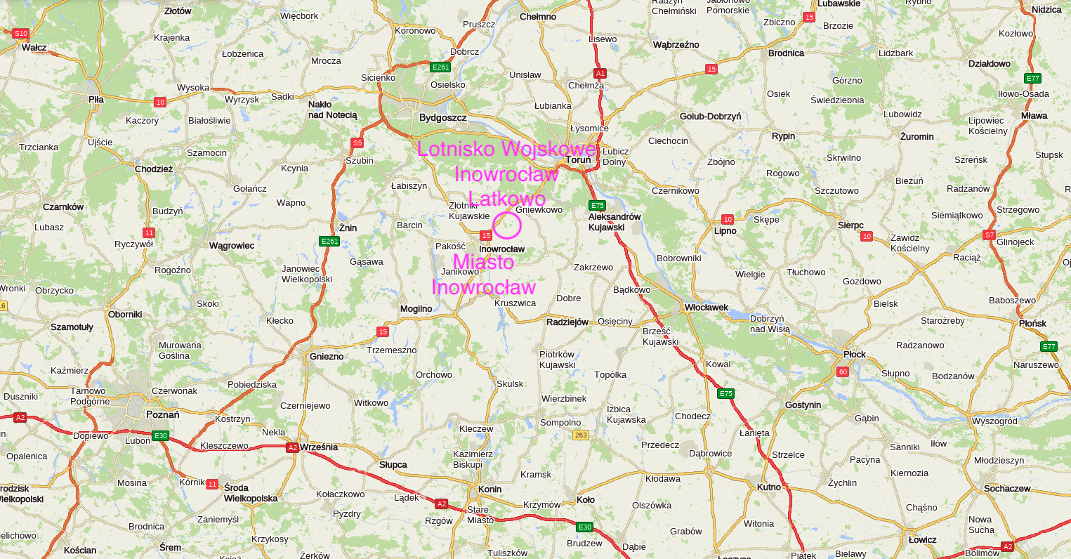
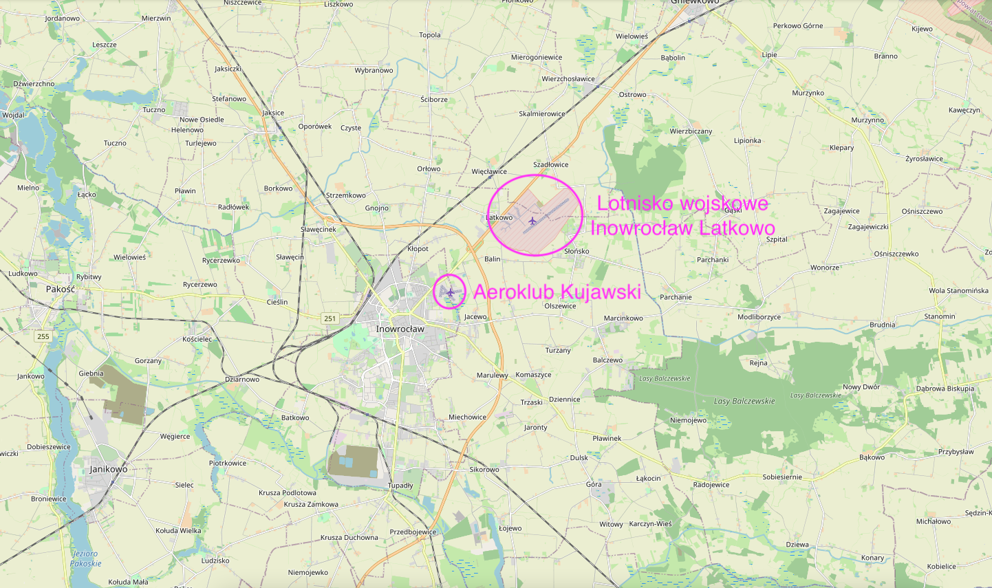
Pierwsze Lotnisko leży przy Szosie Toruńskiej, w granicach administracyjnych Miasta i jest własnością Aeroklubu Kujawskiego. Kod EPIN.
Drugie Lotnisko leży także przy Szosie Toruńskiej, jednak dalej, 5 km od centrum Miasta i jest Lotniskiem Wojskowym, 56. Baza Lotnicza.
W 1980 roku, w Inowrocławiu przy szpitalu (ulica Poznańska) oddano do użytku lądowisko dla śmigłowców Pogotowia Ratunkowego.
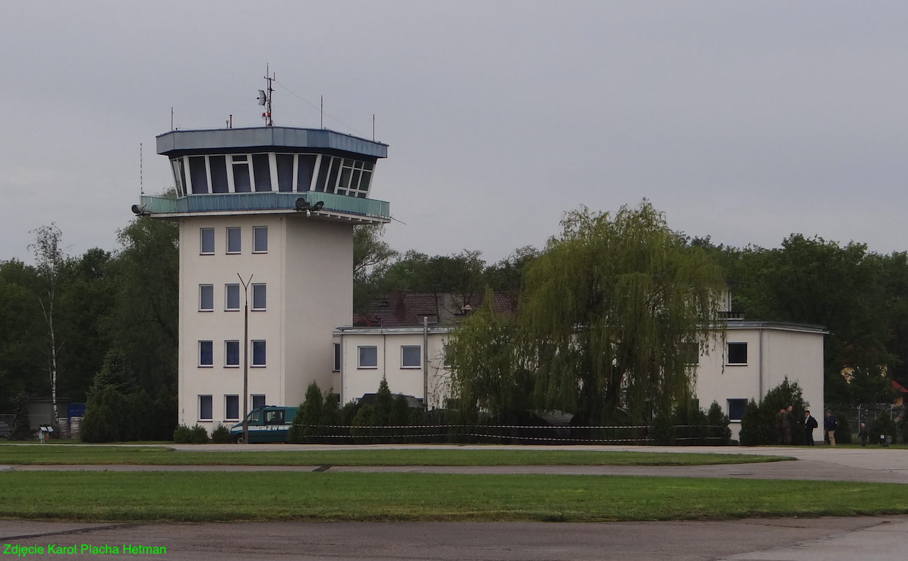
Lotnisko 56. Bazy Lotniczej EPIR. 1952 rok.
Nie wiadomo dokładnie, kiedy powstało drugie Lotnisko w Inowrocławiu. Najprawdopodobniej stało się to w okresie II wojny światowej, kiedy okazało się, że istniejące Lotnisko dysponuje za krótkim polem wzlotów. Maksymalnie 800 m. Ponieważ pierwsze Lotnisko dysponowało dobrym zapleczem i pobliskimi koszarami, nowe pole wzlotów zorganizowano w odległości niespełna 3 000 m dalej, w miejscowości Latkowo. Ten teren do tej pory był wykorzystywany przez wojska artyleryjskie.
Po zakończeniu II wojny światowej, pierwsze Lotnisko powróciło w ręce cywilów. Natomiast drugie Lotnisko pozostało w rękach Lotnictwa Wojskowego.
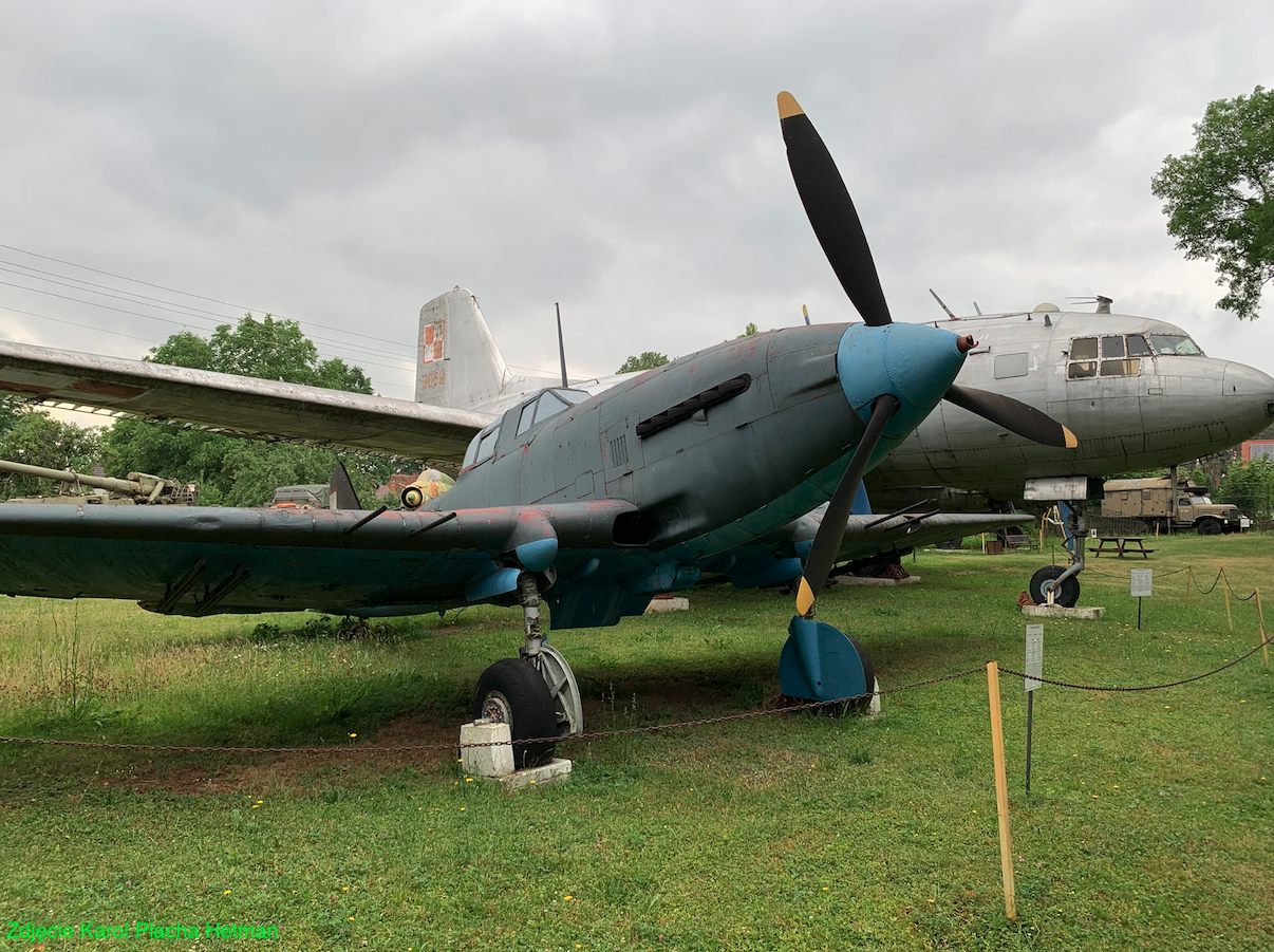
Pierwszym oficjalnym gospodarzem Lotniska Latkowo w 1952 roku, został 48. Pułk lotnictwa Szturmowego, który w tym czasie utworzono. 48. Pułk otrzymał na wyposażenie tłokowe samoloty szturmowe Iliuszyn Ił-10. Bazą dla kadry i żołnierzy stały się koszary przy ulicy Jacewskiej.
Koszary przy ulicy Jacewskiej to jeden z dwóch kompleksów koszarowych w Inowrocławiu. Zostały zbudowane w okresie 1900 – 1903, przez prusaków (zarazę germańską), dla formacji artylerii polowej. Kompleks koszarowy składał się z dwóch dużych gmachów i kilku mniejszych. Umieszczono tu; sztab, wartownię, izby koszarowe, kantynę, kasyno, kuchnię, stołówkę, izbę chorych, magazyny, stajnie, zbrojownię, warsztaty. Po wielkiej wojnie światowej, w 1920 roku, koszary zostały zajęte przez Polski Powstańczy Nadgoplański Oddział Kawalerii, a od 1925 roku, przez 4. Pułk Artylerii Lekkiej.
Już w drugiej połowie 50-lat, 48. Pułk lotnictwa Szturmowego miał kłopoty sprzętowe. Samoloty Ił-10 i ich licencyjne wersje AVIA B.33, nie odpowiadały już współczesnemu polu walki. Z uwagi na brak nowych konstrukcji, w Polsce w ich miejsce wprowadzono samoloty Lim-2. Jednak te samoloty wymagały raczej betonowych dróg startowych. Dlatego Pułkowi groziło przeformowanie lub rozformowanie. W 1960 roku, na bazie 48. PLSz, (który bazował nie tylko w Inowrocławiu, ale także w Bydgoszczy), sformowano 20. Eskadrę Lotnictwa Artyleryjskiego. Eskadrę wyposażono w śmigłowce SM-1, SM-2 i podporządkowano 8. Dywizji Lotnictwa Szturmowego. Na dowódcę Eskadry wyznaczono mjr pilota Stefana Różańskiego. Pod koniec 1960 roku, 48. PLSz, jako jeden z dwóch ostatnich zakończył eksploatację samolotów z napędem tłokowym i przesiadł się całkowicie na samoloty z napędem turboodrzutowym. (Ten drugi Pułk to był 53. PLSz). 48. PLSz został całkowicie przeniesiony do Bydgoszczy. W 1967 roku, w wyniku reorganizacji 48. PLM-Sz został rozformowany.
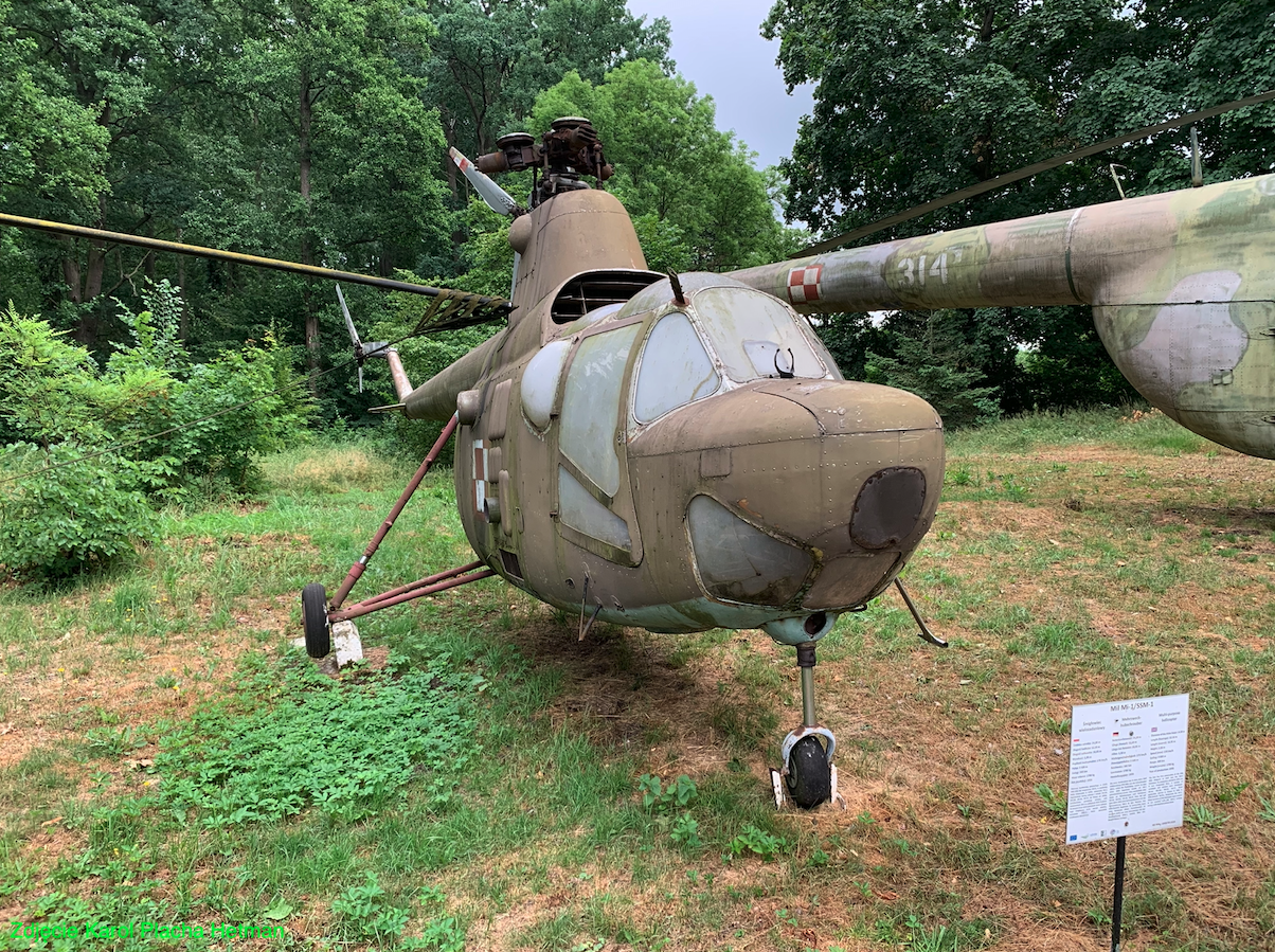
Od 1960 roku, lotnisko Latkowo stało się miejscem bazowania wojskowych śmigłowców należących do 56. Pułku Śmigłowcowego. Patrz osobny artykuł, o 56. Pułku Śmigłowcowym.
Lotnisko Latkowo dysponuje współrzędnymi; N 52 stopnie 49 minut 40 sekund, E 18 stopni 19 minut 20 sekund. Leży na wysokości 77 m nad poziomem morza. Kod Lotniska ICAO – EPIR. Częstotliwości radiowe; INFO 128,500 MHz, TWR 136,650 MHz. Całkowita powierzchnia Lotniska to 192 hektary. Przez wiele lat Lotnisko wyposażone było w drogę startową o wymiarach 2 300 m x 60 m, o nawierzchni gruntowej, o orientacji 05/23. Od kilkunastu lat utrzymywana jest RWY o mniejszych wymiarach. Jednak obecnie (2013 roku) na Lotnisku Latkowo nie lądują samoloty. Przy drodze startowej zlokalizowano płytę przyziemienia i startu śmigłowców. Ma ona nawierzchnię betonową i wymiary około 40 m x 40 m. Oprócz niej, na polu wzlotów są jeszcze dwie mniejsze płyty przyziemienia śmigłowców. Są one zlokalizowane bliżej głównego hangaru. Mają także betonową nawierzchnię i wymiary około 20 m x 20 m. Betonową nawierzchnią dysponują drogi kołowania oraz stojanki śmigłowców. Łączna długość dróg kołowania wynosi około 3 000 m. Lotnisko dysponuje 32 podstawowymi stojankami zgrupowanymi w dwóch grupach, po 16 miejsc. W sporej odległości od głównych obiektów lotniska umiejscowiono jeszcze 5 kolejnych stojanek. Na Lotnisku jest jeszcze kilka innych stojanek. Lotnisko nie dysponuje terenami zalesiony, więc nie ma na nim odosobnionych stref rozśrodkowania. Na Lotnisku nie ma także schron hangarów. Są one zbędne, gdyż w sytuacji konfliktu, śmigłowce bojowe, jako pierwsze ruszą do walki.
56 Baza Lotnicza dysponuje Lotniskiem w Latkowie i koszarami w Inowrocławiu przy ulicy Jacewskiej 73. Kadra jednostki w większości zamieszkuje w osiedlach mieszkalnych Inowrocławia.
Lądowisko dla śmigłowców przy szpitalu.
Lądowisko dla śmigłowców przy szpitalu (ulica Poznańska) zostało oddane do użytku w 1980 roku. Zostało zlokalizowane na zapleczu kompleksu szpitalnego. Praktycznie był to utwardzony plac oznaczony znakami poziomymi. Takie wówczas były standardy. Śmigłowce operowały z niego tylko w dobrych warunkach pogodowych. Z czasem lądowisko otrzymało oświetlenie, które pozwoliło na wykonywanie lotów w nocy w dobrych warunkach pogodowych. W 2010 roku, kiedy Polskie Lotnicze Pogotowie Ratunkowe otrzymało nowe śmigłowce, zaistniała konieczność zmodernizowania lądowiska. Inowrocławski szpital otrzymał fundusze, z Ministerstwa Zdrowia na przebudowę lądowiska. Koszt modernizacji wyniósł 3 270 000 złotych. Tempo prac uzależnione było od panujących warunków atmosferycznych. Przebudowa obejmowała remont całej płyty lądowiska, z podgrzewaniem. Wykonano nowe oświetlenie, stację pogodową, nową łączność radiową. Teren ogrodzono. Istotną inwestycją było zbudowanie tunelu. Został on wykonany z poliwęglanu na stalowej konstrukcji. Dzięki temu tunelowi, pacjenci są transportowani do/ze śmigłowca oddzielni od warunków atmosferycznych (deszcz, śnieg, wiatr, niskie temperatury) i o każdej porze dnia i nocy.
Opracował Karol Placha Hetman