Kraków 2013-02-04
Nawigacja.
Podstawy Geografii w lotnictwie.
Nie można mówić o nawigacji w lotnictwie nie znając podstaw geografii. Zacznijmy od tego, jak wygląda Ziemia. Jej kulisty kształt potwierdzili żeglarze podczas wielkich odkryć geograficznych (1450r.-1650r.). Potem były zdjęcia wykonane z balonów stratosferycznych i pierwszych sztucznych satelitów Ziemi. Na własne oczy zobaczyli ją z kosmosu kosmonauci i astronauci.
Planeta Ziemia.
Ziemia zwana jest po łacinie Terra. Jest trzecią, licząc od Słońca, a piąta, co do wielkości planetą Układu Słonecznego. Pod względem średnicy, masy i gęstości jest to największa planeta skalista Układu Słonecznego. Kształt Ziemi zbliżony jest do elipsoidy obrotowej. Ruch obrotowy Ziemi sprawia, że średnica równika jest o 43 km większa niż średnica pomiędzy biegunami. Przeciętna średnica wynosi 12 742 km. Można powiedzieć, że Ziemia jest kulą spłaszczoną na biegunach. To spłaszczenie wynosi zaledwie 21,385 km. Rzeczywisty kształt planety jest nazywany geoidą, czyli jest to powierzchnia prostopadła do pionu w każdym jej punkcie. Geoida zerowa pokrywałaby się z powierzchnią oceanów przy pełnej równowadze znajdujących się w nich mas wodnych. Odchylenia geoidy od idealnej elipsoidy wynoszą od -106 m do 85 m. Ponieważ nieregularności geoidy mogą mieć znaczenie przy dokładnym określaniu położenia, przy pomiarach i obliczeniach geodezyjnych preferowane jest odniesienie do elipsoidy. Dla porównania, różnica między geoidą, a elipsoidą jest tak mała, że gdyby Ziemia była kulą bilardową to miałaby mniejsze zniekształcenia niż prawdziwa kula bilardowa. (Tolerancja dla Ziemi 0,17 %, tolerancja dla kuli bilardowej 0,22 %.). Największe lokalne odchylenia powierzchni Ziemi to Mount Everest (8 848 m n.p.m.) i rów Mariański (10 911 m p.p.m.). Powierzchnia Ziemi wnosi 510 072 000 km². Na Ziemi wyróżnia się do siedmiu kontynentów, w kolejności od największej do najmniejszej powierzchni: Azja, Afryka, Ameryka Północna, Ameryka Południowa, Antarktyda, Europa i Australia. Powierzchnia lądów wynosi 148 940 000 km² lądu (29,2%). Wyróżnia się też trzy, cztery lub pięć oceanów. W systemie pięciu oceanów, w kolejności od największej do najmniejszej powierzchni wymienia się: Ocean Spokojny, Ocean Atlantycki, Ocean Indyjski, Ocean Południowy i Ocean Arktyczny. Powierzchnia oceanów wynosi 361 132 000 km² wody (70,8%). Kilka danych matematycznych dotyczących Ziemi; Promień równikowy 6 378,1366 km. Obwód na równiku 40 075,014 km. Promień biegunowy 6 356,8 km. Obwód wzdłuż południków 40 007 km. Przeciętny promień 6 371,0 km.
To, co nas głównie będzie interesowało w geografii to; kartografia (sztuka sporządzania i badania map), geodezja (badająca położenie i dystans) oraz nawigacja (zajmująca się pozycją na powierzchni Ziemi).
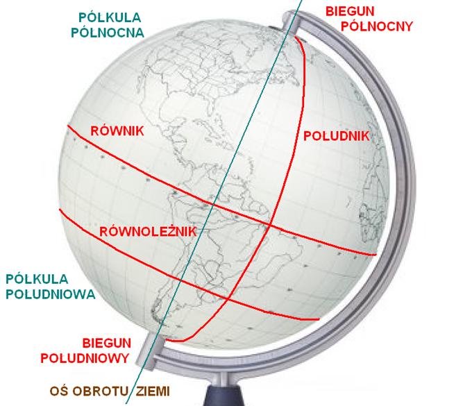
Siatka geograficzna Ziemi.
Mapy kompasowe w okresie wielkich odkryć geograficznych stały się niewystarczające. Jednocześnie okazało się, że nasza Ziemia (niezależnie od sposobu jej wyobrażenia) w rzeczywistości jest około czterokrotnie większa niż ją znano. Że nie ogranicza się tylko do Europy, Afryki i Azji. Udowodniono, że jest kształtem zbliżona do kuli. Trzeba było, więc stworzyć nowy układ odniesienia. Powrócono do nauki Ptolemeusz Klaudiusz. Klaudiusz Ptolemeusz lub po prostu Ptolemeusz żył w II wieku n.e. Był astronomem, matematykiem i geografem greckiego pochodzenia. Należał do tych uczonych, którzy uważali, że Ziemia jest sferyczna lub nawet kulista. Ptolemeusz był pierwszym człowiekiem w historii, który wykorzystał siatkę geograficzną w kartografii. Jego definicja szerokości geograficznej (równik 0°, bieguny ±90°) obowiązuje do dziś. Na początku XVI wieku powrócono, więc do idei siatki geograficznej.
Siatka geograficzna to wirtualny układ południków i równoleżników na Ziemi lub rzeczywisty na globusie, który jest modelem Ziemi. Siatkę geograficzną tworzą południki biegnące przez oba ziemskie bieguny (Wszystkie mają jednakową długość) oraz równoleżniki, których płaszczyzna jest prostopadła do osi obrotu ziemi biegnącej przez oba bieguny (Czym bliżej bieguna, tym obwód równoleżnika jest mniejszy). Jak sama nazwa wskazuje, równoleżniki są równoległe do siebie. Najdłuższym równoleżnikiem jest równik. Południk zerowy (0 stopni) i równik ziemski (0 stopni) tworzą układ odniesienia, względem,którego wyznacza się współrzędne geograficzne. Równik podzielono na 180 stopni na wschód i 180 stopni na zachód. Południki z kolei od równika do bieguna na 90 stopni na północ i na południe.
Dlaczego koło ma 360 stopni?
Dlaczego koło ma 360 stopni? Pytanie o tyle zasadne, że przez kilka wieków żeglarze używali map rumbowych, a później kompasowych. Ich podstawą była siatka utworzona na bazie róży wiatrów. Róża wiatrów była zwykle podzielona na 32 części zwanych rumbami, więc stopnie mogłyby być związane z tymi rumbami. Tak się jednak nie stało. W starożytności Babilończycy zauważyli, że w zależności od położenia słońca nad horyzontem zmienia się kąt padania promieni słonecznych, a ponieważ rok podzielony był na 12 miesięcy po 30 dni, to jest na 360 dni, więc koło podzielono też na 360 równych części. Wiemy także, że Babilończycy nie stosowali systemu dziesiętnego, tylko m.in. dwunastkowy i sześć-dziesiątkowy. Dla nich 360 to całkiem równa liczba. I tak podział kąta pełnego na 360 stopni przetrwał do dziś. To wytłumaczenie wydajesię logiczne.
Południk zerowy.
Już w II wieku naszej ery Ptolemeusz wykorzystał najbardziej na zachód wysunięty znany sobie ląd, jako południk odniesienia, dzięki czemu współrzędne geograficzne wszystkich punktów na znanym wówczas świecie były wschodnie i według przyjętej konwencji dodatnie. Od XVI wieku za punkt, przez który przebiega południk zerowy, przyjmowano hiszpańską wyspę El Hierro, zwaną Wyspą Południkową, leżącą u zachodnich wybrzeży Afryki. Wykorzystywano go, jako odniesienie do wykreślania map i dokonywania obliczeń geograficznych, szczególnie przez żeglarzy i geografów spoza Wielkiej Brytanii. Od 1884 roku, obowiązującym południkiem zerowym (na 100 lat) stał się południk przechodzący przez obserwatorium astronomiczne w dzielnicy Greenwich w Londynie. W związku z rozwojem techniki, w szczególności techniki satelitarnej, DepartamentObrony Stanów Zjednoczonych opracował dokładniejszą siatkę geograficzną, wzorowaną na dokładniejszym modelu Ziemi. Projekt nosił nazwę WGS (World Geodetic System) i w 1984 roku, zdecydowano się zastąpić dotychczasową siatkęgeograficzną siatką WGS 84. Z założenia miała ona doprecyzować (ale nie zmienić) dotychczasową siatkę. Jednak nie uniknięto przesunięć południków, w tym zmiany położenia południka zerowego, który został przesunięty o około 102 metryna wschód od swojego poprzednika. Tak, więc w 1984 roku, południk zerowy na podstawie WGS 84 zastąpił dotychczasowy Południk Greenwich. Południk zerowy nadal przechodzi przez park Greenwich, ale już nie przez historyczne obserwatorium astronomiczne. Jednak poprzedni południk zerowy jest nadal nakreślony na dziedzińcu obserwatorium, chociaż stracił swoje znaczenie pomiarowe. Swoją magią podziału globu na półkulę wschodnią i zachodnią przyciąga tysiące turystów zupełnie niezorientowanych, że obowiązujący południk zerowy znajduje się 102 metrów dalej na wschód. Obecnie siatka WGS 84 jestjedyną obowiązującą siatką geograficzną na świecie. Na niej wzorowany jest system nawigacji satelitarnej GPS, czas UTC oraz wszystkie mapy. W związku z zastosowaniem siatki geograficznej WGS 84 swoje koordynaty zmienił również Południk Warszawski z 21 00′ 42" (do 1984 roku) na 21 00′ 35" długości geograficznej wschodniej.
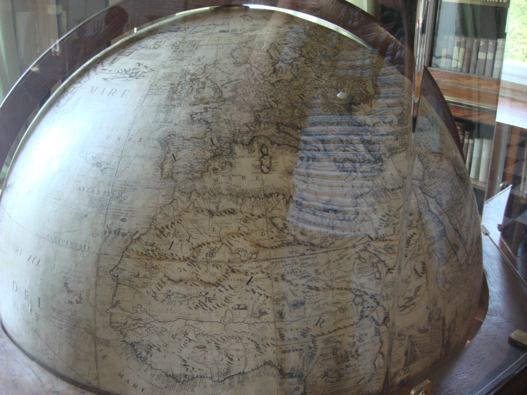
Globus.
Globus (od łacińskiego słowa globus – kula) to jest pomniejszony model ciała niebieskiego (najczęściej Ziemi) lub sferyniebieskiej w postaci kuli umieszczonej na osi ustawionej pod kątem odpowiadającym kątowi nachylenia osi danego ciała, na powierzchni, której znajduje się mapa pierwowzoru. Zaletą globusa jest brak zniekształceń, które pojawiają się przy odwzorowaniu obrazu terenu (mapy) na płaszczyźnie. Najstarszym istniejącym globusem jest globus Martina Behaima z 1492 roku. Najstarszym w Polsce jest globus z około 1508 roku, zwany Jagiellońskim, jest on jednym z pierwszych, na których oznaczono Amerykę.
Idealnym do nawigacji dalekomorskiej i lotniczej byłby globus. Na nim najłatwiej byłoby wyznaczyć nawigatorom najkrótszą drogę. Lecz taki globus musiałby mieć duże wymiary, a korzystanie z niego byłoby utrudnione. Dlatego układ przestrzenny (jakim jest kula ziemska), przeniesiono na dwuwymiarowy papier. Siatka geograficzna stała się siatką kartograficzną, czyli układem południków i równoleżników na płaszczyźnie, na mapie.
Mapa.
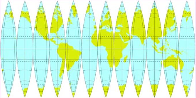
Istotą odwzorowania kartograficznego jest sposób przeniesienia obrazu z trójwymiarowej powierzchni kuli na dwuwymiarowąpłaszczyznę lub pomocnicze powierzchnie rozwijalne, którymi są pobocznice stożka lub walca. Przy czym każda z nich może być styczna do powierzchni kuli (elipsoidy) lub przecinać ją wzdłuż pewnych linii, czyli być sieczną. Stąd podział odwzorowań kartograficznych na: – azymutalne (płaszczyznowe, zachowują azymuty), – stożkowe, – walcowe, – umowne (modyfikacje trzech pierwszych). Mało tego. Ze względu na zniekształcenia wynikające z odwzorowania, odwzorowania mogą być: wiernokątne, wiernopolowe, wiernoodległościowe, dowolne.
Jak więc widać, możliwości jest bardzo dużo. Wszystko zależy od tego jak duży obszar nas interesuje (cała ziemia, jeden kontynent, jeden kraj) i jakim celom przyszła mapa ma służyć. Dla nawigacji morskiej, lotniczej, potrzeb militarnych i stref czasowych; stosuje się rzuty walcowe, w których wszystkie koła odwzorowują się jako linie proste. Siatka walcowa zostałaskonstruowana przez flamandzkiego kartografa Merkatora w 1569 roku. Południki i równoleżniki są na niej liniami prostymi i przecinają się pod kątem prostym, tak jak na globusie. Rzut ten spełnia podstawowe warunki dla mapy morskiej i lotniczej. Jest zachowana wierność kątów i zachowana jest wierność odległości. Możliwe jest wykreślanie kursów i poruszać się po loksodromie. Czasami mapy morskie wykonuje się też w rzucie gnonomicznym dla pokazania obszarów podbiegunowych oraz dla żeglugi po ortodromie. Odwzorowanie na równiku jest dokładne, ale wraz z oddalaniem się od niego błędy rosną, gdyż na odwzorowaniu wszystkie równoleżniki mają te same długości. Prowadzi to do ogromnych deformacji wyglądu obszarów w okolicach bieguna. (Samych biegunów, w takich rzutach nie da się odwzorować). Z tych powodów jej używanie ma sens tylko w nawigacji, gdyż bardzo łatwo znaleźć na takiej mapie dowolny punkt o zadanych współrzędnych geograficznych oraz wyznaczać azymuty.
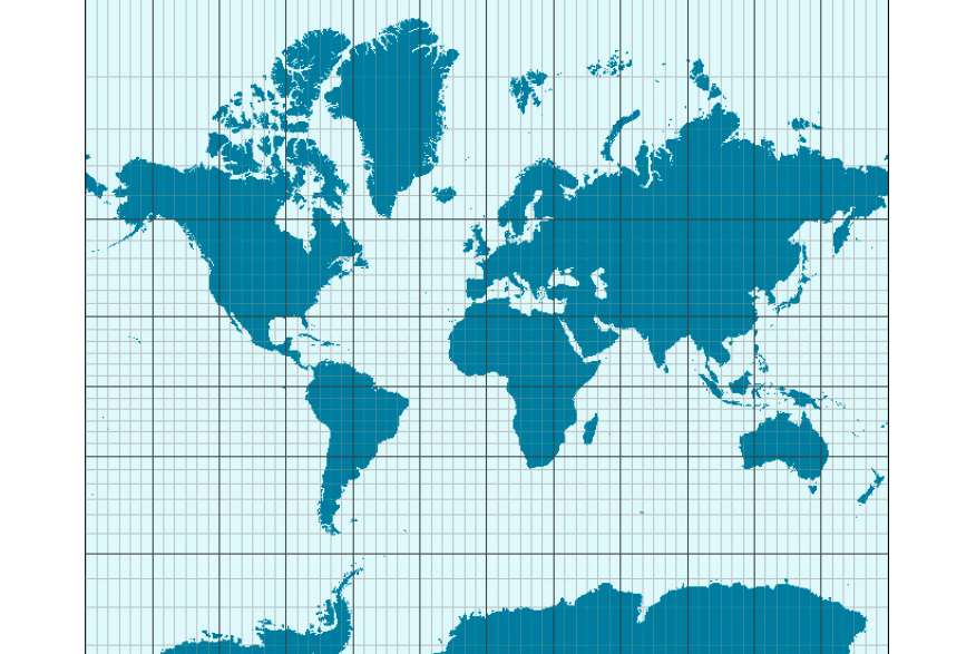
Proszę zauważyć, że Grenlandia ma powierzchnię Afryki, największym kontynentem jest Antarktyda, co oczywiście jest błędem tego typu odwzorowania. Natomiast wszystkie południki i równoleżniki są proste i przecinają się pod kątem prostym, jak na globusie. Oczywiście, wyżej pokazaną mapę można poprawić poprzez zachowanie wiernopowierzchniowe, czyli zachowania innych odległości kolejnych równoleżników.
Siatka geograficzna ma podstawowe znaczenie do określania położenia punktów na Ziemi przy użyciu konkretnych liczbowych współrzędnych geograficznych, zwanych także koordynantami geograficznymi. Zalicza się do nich długość i szerokość geograficzną. Długością geograficzną nazywamy kąt, zawarty między dwiema półpłaszczyznami, z których pierwsza wyznaczona jest przez południk zerowy, a druga przez południk przechodzący przez dany punkt. Przyjmuje ona wartości 0°-180° na wschód (E – ang. East) bądź na zachód (W – ang. West) od południka zerowego. Szerokość geograficzna wyznacza kąt zawarty między płaszczyzną równika a promieniem ziemskim poprowadzonym ze środka Ziemi do danego punktu. Może ona przyjmować wartości 0°-90° zarówno na północ (N -ang. North), jak i na południe (S – ang. South) od równika.
Polska kartografia.
Dla Polskiej kartografii szczególnie zasłużoną postacią jest Eugeniusz Romer, wybitny geograf żyjący w okresie 1871 – 1954.Jego Atlas geograficzny z 1908 roku, wydawany był przez 56 kolejnych lat. Romer stosował różne skale map, rzeźbę terenu przedstawiał poziomicami, propagował odwzorowanie wiernopowierzchniowe Lamberta, używał konsekwentnej skali barw ijako pierwszy na świecie zaprezentował zjawiska społeczno-gospodarcze metodą izolinii. Stosowane przez niego metody prezentowania zjawisk geograficznych stały się podstawą dla Polskiej szkoły kartograficznej. Podwaliny dla Polskiej kartografii tworzył także Wojskowy Instytut Geograficzny (WIG). WIG stworzono w 1919r., aby zebrać wszelkie materiały geodezyjne i kartograficzne poświęcone ziemiom odrodzonej II Rzeczypospolitej Polski. Sprawdzić je i opracować Polski model mapy topograficznej. W wyniku prac WIG ustalono dla Polskich map poziom wysokości 0 m na linii brzegowej Bałtyku, a południk zerowy w Greenwich, co nie było wcześniej jednoznaczne.
Wyznaczanie trasy.
Dla wielu osób udających się samolotem z Polski do USA wydaje się dziwne, że samolot po starcie zamiast lecieć na zachód (bo tam jest kontynent Amerykański), to leci w kierunku północno-zachodnim, nad Morze Bałtyckie. Inni którzy czasami zaglądają na stronę Filghtradar24 zastanawia, dlaczego samolot z Pekinu do Rzymu przelatuje nad Polską? I właśnie tu postaramy się to wyjaśnić.
Ogólnie mówimy, że podróż to przemieszczanie się z punktu A do punktu B. Jeśli ta odległość wynosi kilka kilometrów, to nie ma większych problemów. Ale kiedy podróż ma wynieść 1 000 km, to może już być problem. W nawigacji chodzi głównie o to, aby przemieścić się z punktu A do punktu B jak najkrótszą drogą. Pozostawimy na boku kwestie; pogody, klimatu, prądów morskich, wiatrów, czy umów i przepisów międzynarodowych. Jak zatem wyznaczyć najkrótszą drogę naszej podróży? Najprostszym sposobem jest mapa oraz nitka, której jeden koniec przykładamy do punktu początkowego (A), a drugi do punktu docelowego (B). Po jej naprężeniu uzyskamy najkrótszą drogę. Jednak przy wielkich odległościach dużo lepszy jest globus. I tak doszliśmy do nowych pojęć; loksodroma i ortodroma.
Loksodroma.
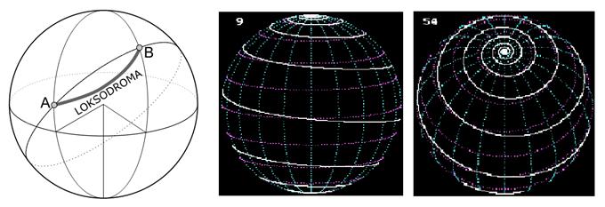
Loksodroma (gr. loksós – ukośny, droma – linia) jest linią krzywą na powierzchni Ziemi, która przecinającą wszystkie południki pod tym samym kątem. Umieszczając loksodromę na globusie otrzymamy linie spiralną która połączy obabieguny Ziemi. Na mapie Merkatora (dokładniej na mapie w rzucie Merkatora) loksodroma odwzorowuje się w postaci linii prostej i jako taka jest powszechnie stosowana w nawigacji morskiej i lotniczej do wykreślania drogi (kursu). Statek płynący stałym kursem, np. korzystając z GPS w rzeczywistości utrzymuje ten sam kąt względem kierunku północ-południe, a więc przecina wszystkie południki pod tym samym kątem – płynie po loksodromie. Loksodroma nie jest najkrótszą drogą łączącą dwa punkty na powierzchni kuli, właściwość taką ma za to ortodroma. Są jednak wyjątki. Loksodroma po południkach i po równiku jest najkrótsza drogą i pokrywa się z ortodromą.
Ortodroma.
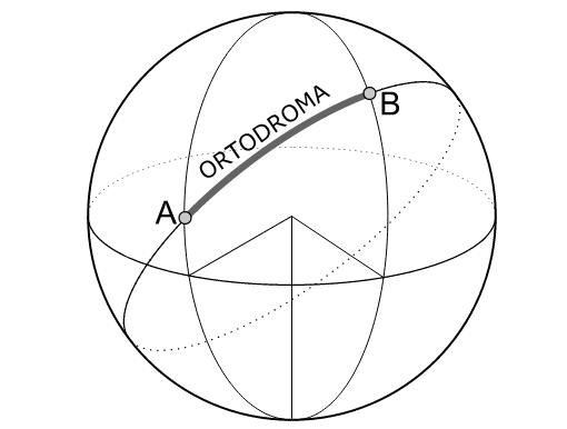
Ortodroma (st.gr. ὀρθόs, orthos = prosty, prawidłowy; δρόμος, dromos = droga, przebieg) – najkrótsza droga pomiędzy dwoma punktami na powierzchni Ziemi. Stanowi ona zawsze fragment koła wielkiego. Linię ortodromy otrzymuje się przezprzecięcie kuli płaszczyzną przechodzącą przez punkty A i B na powierzchni tej kuli oraz przez środek kuli. Na mapie Merkatora (dokładniej na mapie w rzucie Merkatora) ortodroma jest linią krzywą wygiętą w kierunku bliższego bieguna ziemskiego, w przeciwieństwie do loksodromy, która przecina wszystkie południki pod tym samymkątem, a na mapie Merkatora jest linią prostą. Ręczne wyznaczanie ortodromy jest jedną z trudniejszych, a jednocześnie ważniejszych rzeczy w nauczaniu nawigacji, gdyż linią ortodromy powinny poruszać się na dłuższych odległościach wszystkie statki wodne i powietrzne. Trudność w wyznaczaniu kursów na mapach polega na tym, że jedynie drogapo równiku oraz południkach pokrywa się z ortodromą, natomiast we wszystkich pozostałych przypadkach wyznaczenie ortodromy na mapach jest związane z szeregiem skomplikowanych obliczeń. Dlatego właśnie podróż po ortodromie wykonuje się w rzeczywistości z pewnym przybliżeniem, skokowo, odcinkami loksodromicznymi.
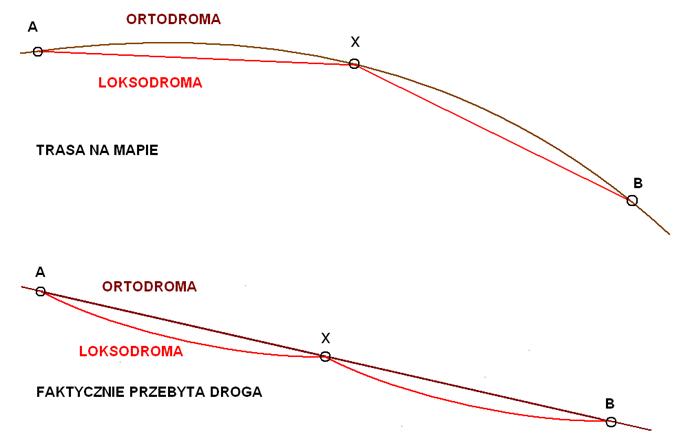
W rzeczywistości poruszanie się po ortodromie i loksodromie łączy się. Całą trasę wyznacza się wstępnie po ortodromie, a następnie dzieli na odcinki, gdzie poruszamy się po loksodromie. Poruszanie się po ortodromie oszczędza energie i czas. Poruszanie się po loksodromie pozwala przemieszczać się stałym kursem czyli sterowanie według busoli (kompasu). Wyznaczanie kursu to cała seria skomplikowanych obliczeń matematycznych. Lecz postęp w nawigacji jest tak duży, że dzisiejsi kapitanowie statków powietrznych i morskich wcale się tym nie zajmują. Z góry mają wyznaczone trasy opracowane przez swoje kierownictwa, a i one korzystają ze specjalistycznych firm. Podobnie jest w wojsku. Tu trasy wyznaczają dowództwa, a kapitan jednostki to wykonuje. Prawdziwą nawigacja zajmują się już tylko dalekomorscy żeglarze, którzy mogąskorzystać z coraz dokładniejszych i bogatych map, ale wyliczanie kursu i pozycji muszą wykonać sami.
Układy jednostek miar.
Jednostki stosowane przy dalekich podróżach różnią się nieco od tych które w Rzeczypospolitej Polskiej używamy na co dzień. Wynika to z przyjętych układów i zaszłości historycznych. Przez wiele wieków ludzie posługiwali się różnymi układami miar i wag. Powodowało to pewne utrudnienia w handlu, a także sprzyjało nadużyciom. Nawet Pismo Święte o tym wspomina. Z czasem dochodziło do negocjacji na szczeblu państwowym. Aż doszło do wielonarodowej I Generalnej Konferencji Miar, w 1889 roku. (Taka konferencja odbywa się co kilka lat, w zależności od potrzeb. Tych konferencji odbyło się już 23.). Na I GKM ustalono wzorzec 1 m (jednego metra) i wzorzec 1 kg (jednego kilograma). System ten przyjęło się nazywać Układ MKS (metr, kilogram, sekunda). W 1960 roku, przyjęto, że są jednostki podstawowe i pochodne i tak powstał Układ SI. Układ SI (franc. Système international d’unités) – Międzynarodowy Układ Jednostek Miar. Jest on co jakiś czas modyfikowany, w zależności od rozwoju nauki. W Polsce Układ SI obowiązuje od 1966 roku. Obecnie Układ SI został oficjalnie przyjęty przezwszystkie kraje świata z wyjątkiem Stanów Zjednoczonych, Liberii i Birmy. O ile Liberia i Birma nie są dużymi gospodarkami, to nie przyjęcie przez USA, pierwszej gospodarki świata, wspólnego układu niesie za sobą pewne konsekwencje. Nie chcemy, napisać, że muszą przyjąć ten układ, bo być może w kwestii miary długości są bliżsi lepszego wzorca, niż wzięty z sufitu wzorzec jednego metra.
Mila morska.
Mila – dawna jednostka długości o różnej wartości, zależnej od rejonu i okresu. Nazwa pochodzi z łac. mille – tysiąc. Początkowo mila oznaczała 1 000 kroków podwójnych. Istniała także Mila Polska. Wynosiła ona (w XVIII wieku) 7 wiorst czyli 7 146 metrów, a od 1819 roku – 8 534,31 m.
Mila morska (Mm, ang.: nautical mile – NM, International Nautical Mile – INM) – jest jednostką odległości stosowaną w nawigacji morskiej. Jest to długość łuku południka ziemskiego odpowiadająca jednej minucie kątowej koła wielkiego. W rzeczywistości ze względu na kształt kuli ziemskiej (geoida) długość łuku 1 minuty kątowej jest różna w zależności od szerokości geograficznej, dlatego umownie przyjęto długość uśrednioną.
1 INM → 1’ stąd: 40 000 km / (360° × 60’) = 1851,852 m ≈ 1 852 m. W układzie SI (wartość przyjęta w Normie ISO 31-2) 1 INM = 10 kabli. Dodatkowo niektóre państwa stosują własną wartość dla mili morskiej: Wielka Brytania – 1853,18 m, Dania – 1851,85 m, Holandia – 1851,85 m, Stany Zjednoczone – 1853,248 m, Portugalia – 1850,00 m, Japonia – 1853,18 m.
Jednostką pochodną 1 mili morskiej jest jednostka zwana "Kabel". Kabel to 0,1 mili morskiej, czyli w przybliżeniu 185,2 m. (Znany jest także Kabel brytyjski i Kabel amerykański).
Mimo wszystko liczba 1 852 wciąż czaruje ludzi związanych z morzem i lotnictwem.
Stopa.
Drugą ważną jednostką długości jest Stopa. Należy ona do dawnych, historycznych miar i nawiązuje do przeciętnej długości stopy ludzkiej. W różnych krajach miała inną długość. Zmieniała się także na przestrzeni wieków. Obecnie przez stopę najczęściej rozumie się stopę angielską (foot) = 30,480 cm, czyli 1 m = 3,280840 stóp. Skrót: ft. Spotyka się również zapis z użyciem apostrofu (np. 50′). 1 stopa = 12 cali = 30,48 cm = 1/3 jarda. 1 cal = 2,54 cm.
Stopa dawniej, najczęściej stanowiła 1/2 łokcia i dzieliła się na 12 cali. W Polsce: stopa staropolska, tj. warszawska – do 1819 roku, = 29,78 cm, stopa galicyjska, tj. lwowska – 1787r.-1856r. = 29,77 cm, stopa wrocławska – do 1816 roku, = 28,80 cm, stopa krakowska – 1836r.-1857r. = 29,8 cm, stopa litewska = ok. 32 cm.
Węzeł.
Z pojęciem mili morskiej związana jest jednostka prędkości węzeł. Węzeł (ang.: knot), w skrócie w. (ang.: kn lub kt albo kts)– jednostka miary, równa jednej mil morskiej na godzinę. Stosowana do określania prędkości morskich jednostek pływających, a w części państw i w ruchu międzynarodowym także statków powietrznych (samolotów, śmigłowców, szybowców, balonów). Ponadto w meteorologii – pomocniczo do określania prędkości wiatrów i prądów morskich (zasadniczą jednostką jest m/s). W żegludze śródlądowej używa się kilometrów na godzinę.
1 w. = 1 nm/h = 1,852 km/h ≈ 0,514444 m/s.
Biegun magnetyczny Ziemi.
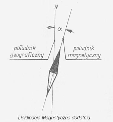
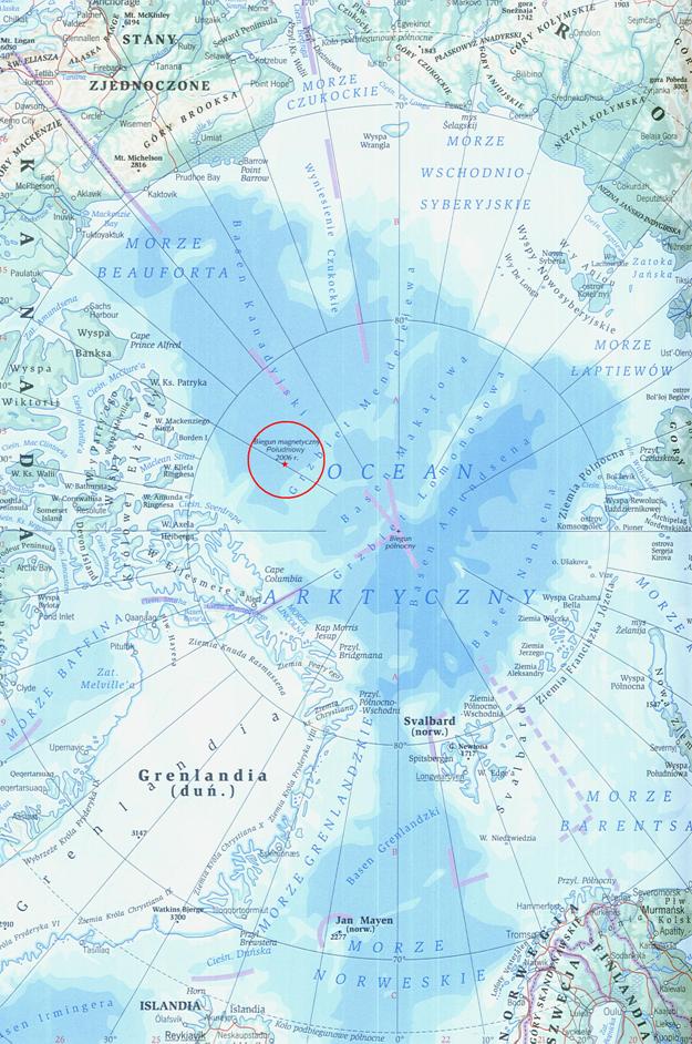
Ziemia zachowuje się tak jak magnes. O właściwościach magnetycznych decyduje będące w ciągłym ruchu płynne jądro Ziemi. Ten ruch płynnego jądra Ziemi wynika głównie z jej ruchu obrotowego. To jądra składa się głównie ze stopionego żelaza z niklem. Układ taki powoduje, że Ziemia ma dwa bieguny magnetyczne, które nie pokrywają się z biegunami geograficznymi, które z kolei wynikają z osi obrotu Ziemi. Bieguny magnetyczne ułożone są odwrotnie niż bieguny geograficzne. Na Antarktydzie zlokalizowany jest północny (to nie pomyłka!) biegun magnetyczny ziemi. Południowy biegun magnetyczny leżynatomiast w kanadyjskiej części Arktyki. Magnetyczny biegun południowy znajduje się w kanadyjskim rejonie Arktyki, około 1 600 km od bieguna geograficznego północnego, a magnetyczny biegun północny leży na Antarktydzie, na Ziemi Adeli,około 2 400 km od bieguna geograficznego południowego. Co istotne przemieszczają się (są w ciągłym, powolnym ruchu). Bieguny magnetyczne przemieszczają się z prędkością około 9 km na rok. W 2007 roku, południowy biegun magnetyczny miał współrzędne: 64°30′S i 137°45′E i był oddalony od bieguna geograficznego o około 2 858 km. W związku z tym wyznaczenie kierunku północy geograficznej za pomocą kompasu wymaga uwzględnienia poprawki zwanej deklinacjąmagnetyczną, która określa kąt pomiędzy płaszczyznami południków, geograficznego i magnetycznego.
Zjawisko to zaobserwowali żeglarze już w XII wieku (czyli przed wielkimi odkryciami geograficznymi). Zauważyli, że namagnesowana igła kompasu nie zawsze dokładnie pokazuje północ. Stwierdził to też Krzysztof Kolumb żeglując przez Ocean Atlantycki. W miarę posuwania się na północ igła kompasu coraz bardziej odchylała się od kierunku północy geograficznej. To pochylanie w dół, tak zwana deklinacją, zwiększało się w miarę oddalania się od równika. Wywnioskowano, że biegun geograficzny i magnetyczny nie pokrywają się.
Pole magnetyczne Ziemi ma jeszcze jedna cechę. Jego linie na równiku są równoległe do powierzchni Ziemi, na biegunach biegną pionowo, zaś w strefie pośredniej biegną pod kątem zależnym od szerokości geograficznej. Dlatego mamy inklinację magnetyczną.
Inklinacja magnetyczna inaczej nachylenie magnetyczne jest kątem zawartym pomiędzy wektorem natężenia ziemskiego polamagnetycznego a horyzontem. Inklinacją nazywamy kąt zawarty pomiędzy płaszczyzną poziomą, a osią swobodnie zawieszonej igły magnetycznej. Wartość inklinacji zmienia się wraz ze zmianą szerokości geograficznej. W Polsce średnio inklinacja wynosi około +66° (na biegunie magnetycznym 90°, na równiku magnetycznym 0°). Linie łączące na mapie punkty o jednakowej inklinacji nazywamy izoklinami.
Deklinacja magnetyczna to kąt poziomy w danym miejscu na powierzchni Ziemi pomiędzy południkiem magnetycznym i geograficznym. Kąt ten podaje się jako wartość ze znakiem, zgodnie ze sposobem liczenia azymutu: odchylenie kierunku północy magnetycznej od kierunku północy geograficznej ku wschodowi jako kąt dodatni, odchylenie ku zachodowi jako kąt ujemny. Wartość deklinacji magnetycznej jest jednym ze składników poprawki kompasu, wielkości uwzględnianej przy pomiarach kompasem magnetycznym.
Deklinacja wywołana jest nie tylko położeniem bieguna magnetycznego Ziemi w innym miejscu niż biegun geograficzny, aletakże lokalnymi warunkami magnetycznymi, jak np. położeniem niektórych rodzajów rud żelaza. W Polsce w rejonie Stąporkowa elektryczne zegarki analogowe mogą pod wpływem sił pola magnetycznego poruszać się do tyłu. Deklinacja magnetyczna jest nanoszona na mapach magnetycznych i niektórych mapach geograficznych (głównie nawigacyjnych).
Biegunem Magnetycznym Ziemi Południowym czasami na mapach opisany jest jako biegun północny co jest niewłaściwe. Wynika to stąd, że bieguny magnesu przyciągają się różnoimienne. Igła kompasu ma biegun północny, który pokazuje (mniej więcej) geograficzną północ, ale kieruje się na biegun magnetyczny Ziemi południowy. Szczerze mówiąc nie jest to najistotniejsze.
Opracował Karol Placha Hetman