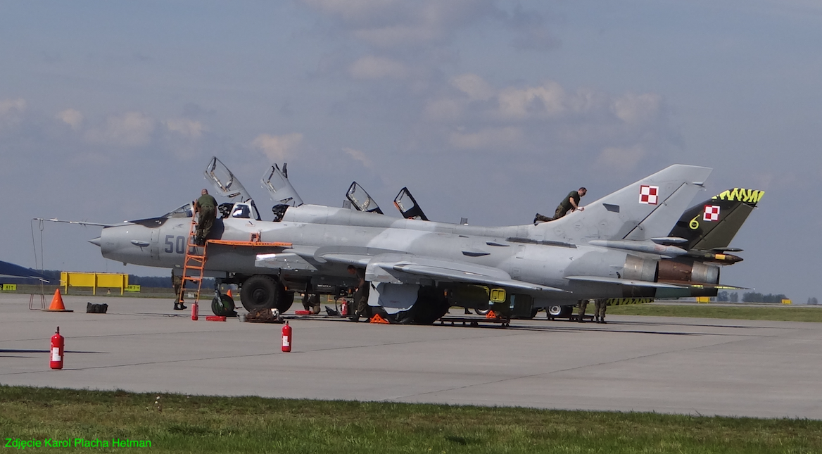
Świdwin 2017-07-29
Airport in Świdwin. 2017.
Geographic coordinates: 53.791N 15.826E. Elevation 116 m (381 ft).
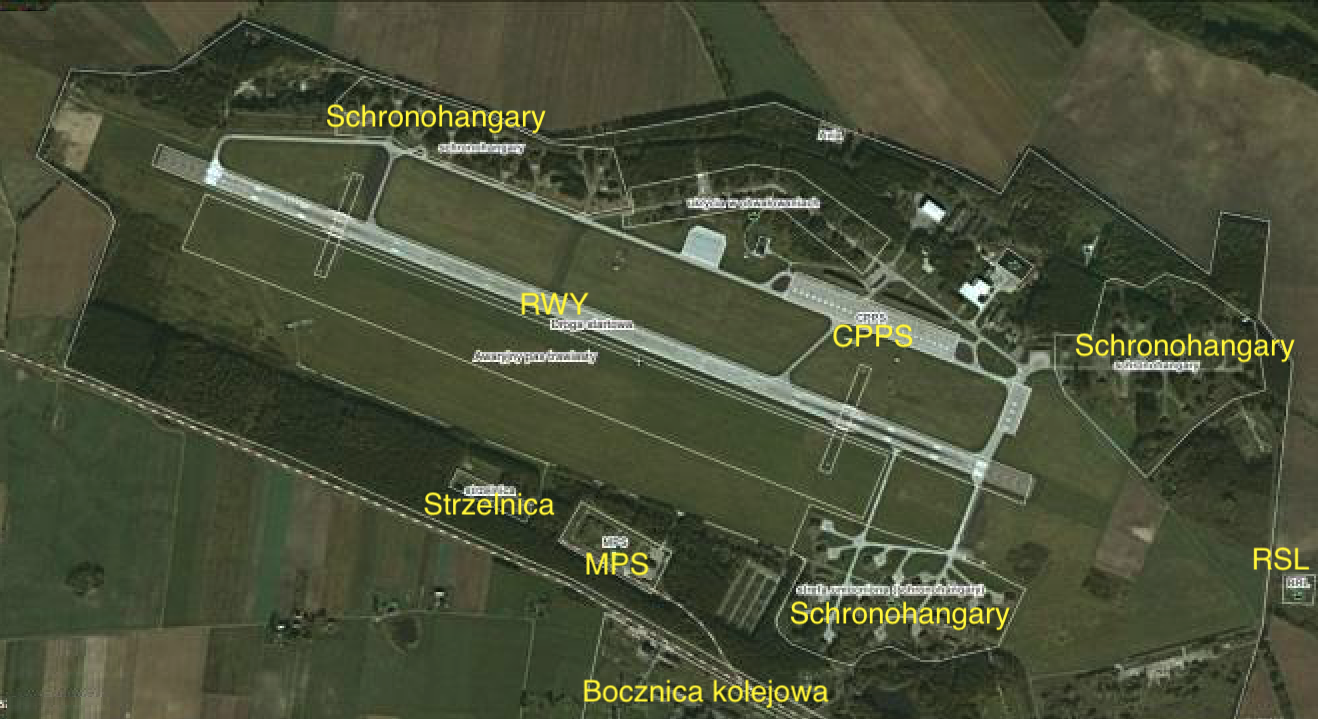
Świdwin Airport infrastructure. 2011.
Świdwin Airport is located in the West Pomeranian Voivodeship. The airport has an EPSN code. It has geographical coordinates 53 47 25 N 15 49 39 E (53.791N 15.826E). It lies at an altitude of 116 m above sea level (381 ft), according to other data 120 m above sea level. Radio frequency info 128.5. Air traffic control tower telephone +48 943822616. PPR T: +48 226821779, F: +48 226821778. WPL commander +48 943823307. Address; st. Połczyńska 32, 78-301 Swidwin 3.
The airport is currently the 21st Tactical Air Base. Military Unit No. 3294. Throughout its history, it has been used exclusively by the army. Passenger or freight traffic has never been carried on it. It is the furthest north-western active Polish Military Airport. There is no civilian movement, but theoretically there is such a possibility. Applications for permission to land domestic civil aircraft should be submitted to the Head of Air Traffic Services of the Polish Armed Forces within 7 days before the planned arrival (tel.: +48-22-682-1779, fax: +48-22-682-1778) . Applications for permission to land foreign civil aircraft must be submitted to the Air Force Command within 21 days before the planned arrival (tel: +48-22-682-5750, fax: +48-22-682-5480) in accordance with applicable regulations in the Polish Armed Forces. Irrespective of obtaining consent, it is required to notify the AFIS authority of the intention to perform the flight on the day preceding the operation. Arrangements for the operation of flights from the airport, handling, refueling, security of the aircraft only with the airport operator.
The 21st BLotT airport is open 24 hours a day, serves as an alternate airport for F-16 aircraft, is also an interoperable airport and secures Air Policing and Renegade missions. There are about 300-400 air operations per month, about 4,000 per year, and all of them are conducted in English.
The 21st Tactical Air Base is currently home to: the Command of the 1st Tactical Air Wing, the 40th ELT, the 8th ELT, the 7th ELT, the Military Barracks Administration, the Military Police Post and the 1st Search and Rescue Group. The latter reports to the Commander of the 3rd Transport Aviation Wing in Powidz. At the Świdwin airport, the search team is on duty 24/7 in the search and rescue system throughout Poland. The group is equipped with Sokół and Mi-2 helicopters.
To secure the flight training process, a flight simulator of the Su-22 aircraft was installed, which was moved from Powidz, where the second simulator was used, mainly for training activities in special situations and for training the combat use of the aircraft.
RWY with dimensions of 2,500 m x 60 m, in the direction of 11/29. Concrete surface (PCN 52/R/A/W/T) 150,000 square meters. In 2012, a renovation was carried out and RWY was equipped with an emergency landing roll shortening system for Lockheed Martin F-16 aircraft in both directions. On the southern side of the RWY, an emergency runway was placed, with a ground-grass surface, with dimensions of 2,000 m x 100 m.
The airport is equipped with a full set of radiolocation and communication devices. Both the post-Soviet system and modern ILS and TACAN systems. The ILS system was installed in 2008, mainly due to the adoption of the F-16 Jastrząb aircraft in the Polish Air Force. The airspace is monitored by a radiolocation system, the main element of which is the AVIA radiolocation station, made in Poland. Its basic parameters; detection range of at least 120 km, detection ceiling of at least 10,000 m.
Navigation equipment (Equipment with radio navigation aids) in 2011: ILS GP frequency 332.750 MHz. ILS LLZ mark ISN frequency 111.550 MHz. DME sign ISN frequency CH52Y. NDB mark ND frequency 280,000 kHz. TACAN mark TSN frequency CH107X. ATS radio communication equipment: AFIS Świdwin INFO – 127.500 MHz – H24. AFIS Świdwin INFO – 128.500 MHz – H24. TWR Świdwin WIEŻA / TOWER – 127.500 MHz – H24.
The main taxiway runs from the north side of the RWY. The side lanes connect the main taxiway with the hangars and staging areas. In total, there are about 5,000 m of taxiways at the airport.
Centering zones. In the 50s, in the northern part of the airport, 28 individual stands for aircraft were located along the curved taxiway. In the 1960s, some of these sites were surrounded on three sides by earth embankments about 4 m high. Currently, this dispersal zone is no longer used and has partially changed. The second aircraft distribution zone with 14 shelter hangars is located in the north-western part of the airfield. In the third dispersal zone in the north-eastern part of the airport, 14 shelters were placed. The fourth aircraft dispersal zone was located in the south-eastern part of the airport. There are also 14 shelters. This is the youngest zone. It has the latest solutions. Its construction was completed at the beginning of the 90s of the 20th century. In total, the airport has 42 shelters.
The airport has three aircraft parking areas, including one central. CPPS was built in the 70’s. It has dimensions of 500 m x 70 m and an area of 35,000 square meters. A new PPS with dimensions of 100 m x 100 m and an area of 10,000 square meters was placed next to the air traffic control tower. It was built at the beginning of the first decade of the 21st century. There is also an eastern PPS with dimensions of 150 m x 50 m and an area of 7,500 square meters. In addition, we must remember about the slabs in front of hangars and shelters.
The airport has three hangars located in the northern part. The two older ones have bases measuring approximately 60 m x 40 m. The third, newest one, commissioned in 2006, is slightly smaller, but very modern. The air traffic control tower is located on the main taxiway, next to the CPPS. The tower is a complex together with the Pilot House. It is a five-story building. The tower was built in the 1960s and has been renovated and expanded several times.
The airport has full facilities. It includes; MPS, classic and airplane shooting ranges, airport guards and others. The airport guard operates in the A4 category. He has at his disposal; car Jelcz 014 GCBA 5/32, car Tatra 815 GCBA 8/32, car Star 29 GPR, car Star 244 GBDA and "HOLMATRO" type technical rescue equipment, foam-forming, synthetic extinguishing agent. There is also a unit of the Airport Meteorological Office at the airport; Tel: +48-94-382-3316, Fax: +48-94-382-3317.
The Smardzko estate is a typical military garrison estate. Over the last 50 years, over a dozen residential blocks for professional soldiers and their families have been commissioned in its area.
PKP.
The airport is located by the railway track No. 421, leading from Świdwin to Połczyn Zdrój. Distance about 25 km. The line is single-track, non-electrified, with low freight traffic. Interestingly, in 1996 passenger traffic was closed. In the following years, freight traffic was irregular, and in 2005 stop it completely. in 2006 cargo traffic on the section Świdwin – Smardzko was resumed, only for the needs of the army and supplies to the Airport. The possible passage of the train takes place only with the consent of the dispatcher at the Świdwin station. The line practically runs through the area of the air base. There are two sidings leading to the airport from this line. First north to the MPS depot. The second to the south to the central heating boiler room, which heats both the barracks and staff part as well as the Smardzko residential estate. During the construction of the airport, most of the necessary materials and raw materials were delivered by rail.
Written by Karol Placha Hetman


