Kraków 2013-05-02
Outline of the history of navigation. Period 1945-1960.
After World War II.
After World War II, radar began to develop even more intensively. At the turn of the 40s and 50s of the 20th century, four more important discoveries were implemented that contributed to the development of radar. The first was the use of the Doppler effect, which improves the detection of moving objects in the presence of other noises coming from, for example, stationary ground objects. The second was the development in 1943 of the monopulse radar, which was developed by Robert Page working in the NRL team in the USA. Thanks to this method, any error comes from one pulse. In the second pulse, this error will no longer be there. This significantly improves tracking accuracy. The third discovery is the Phased-array radar. It is as if there were several radars in one radar and its antenna. Thanks to this, it is possible to switch tracking from one object to another much faster. This, in turn, enabled simultaneous tracking of several objects. The fourth discovery is the Synthetic-aperture radar (SAR). The radar was developed in 1950 at the Goodyear Aircraft Corporation. This method significantly increases the resolution of observed objects. SAR has a wide range of applications, especially in mapping and remote sensing. By 1960, almost all systems and devices known to us today had been discovered and built; they learned to use the Doppler effect. The transistor was invented. The klystron, traveling wave lamps (microwave lamps) were invented. Radars mapping the terrain were built. An onboard pulse-Doppler radar was built, detecting moving targets against the ground. An off-horizon radar was built. Meteorological radars were developed. Radars with digital data processing were created.
Air traffic control in the 1940s.
In the 1940s, the air traffic control system in the USA developed in line with the trends set in the 1930s. Air traffic control centers developed significantly. Every plane in the air was under constant surveillance. Radio communication was established with the crew in a predetermined manner. Information was provided about the expected weather conditions on the flight route and other machines in the vicinity. Information was obtained about the current location, occupied ceiling, course and speed, and about the current weather conditions. In this way, the movements of the plane were monitored. If necessary, additional information was exchanged resulting from; technical problems, running out of fuel, change of flight route, need for a quick landing, etc.
When the plane approaches the airport, the crew establishes contact with the controller working in the air traffic control tower. Information about the current conditions is exchanged. After obtaining permission from the controller about a free RWY, the crew brings the plane down using the ILS system.
The years after World War II were a period of using systems and devices previously built for war purposes, for peaceful purposes. In the USA, the first civilian use of military radars for civilian purposes took place in 1945. The AN/APQ-13 radar, used on board the B-29 bomber for targeting and mapping, was taken as a basis. A ground version of this radar was developed. This system was installed at LaGuardia Airport. It allowed control (tracking) of up to 15 planes near the airport, within an hour. This allowed tracking of an approaching or departing plane continuously for about 4 minutes. The second main purpose of using the radar was to monitor the weather and warn of approaching storms. However, this system was not able to precisely guide the plane to land. The ILS system, known today, was developed a little later. Eventually, about 30 AN/APQ-13 ground radars were built and installed at various airports in the USA.
In 1946, the Civil Aeronautics Administration (CAA), the predecessor of the FAA, publicly presented an experimental radar mounted on a civilian air traffic control tower. This was the beginning of a transformation in air traffic control. Not only radio communication, but also radar. Attempts to perfect the system lasted several years.
In 1950, the AN/APQ-13 radar, as the civilian radar ASR-1 (Aiport Surveillan Radars), was officially adopted in civilian aviation.
In 1954, based on the AN/APQ-13 radar, a variant of the radar was created, which was designated AN/CPS-9. The radar was intended for weather monitoring. The natural consequence was the creation in 1957 of the civilian weather radar WSR-57 (Weather Surveillance Radar).
In 1956, the Civil Aeronautics Administration ordered new long-range radars to use them to control the Atlantic route from the USA to Europe. The initial specification called for the detection of aircraft at high altitudes (up to 10,000 m) and a range of at least 200 NM (370 km). Further development took place in the 1960s.
Europe emerged from the Second World War very crippled. The general distrust of each other, of individual nations, did not and does not favor development. There was a significant division of Europe into two opposing political camps. The Muscovites blocked West Berlin by eliminating all land road and rail routes that connected the West Germans (FRG) with West Berlin. Only the air route remained. In order to ensure control and identification of air traffic to or from West Berlin, the Americans created a very efficient system based on the AN/TPS-44 radar. This radar was mobile, and its main elements were transported on two cars or by rail, or by air (Hercules C-130). Thanks to this, it could be installed in all the troubled regions of the world, including the Middle East, South America and Southeast Asia. This is how the first European system for the security, control and identification of civil-military air traffic was created. This debut took place in 1948. To this day (2013) US troops are stationed in Germany, not to defend the Germans, but to keep an eye on the Germans who would start World War III.
Basic navigational instruments.
The period of 40 years is the common introduction of flight along a route according to radio beacons.
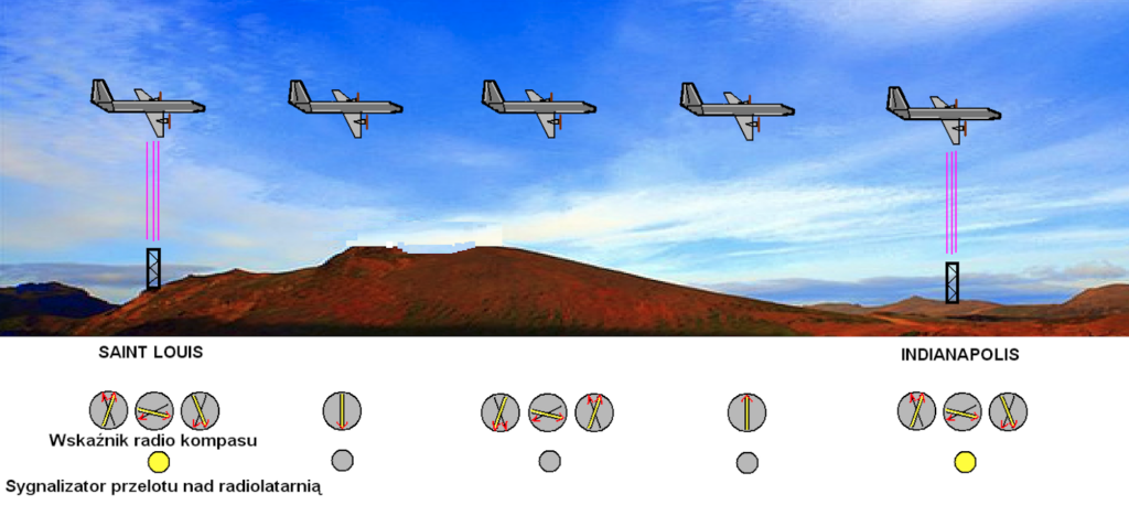
The principle of navigation (LFB system) using radio beacons is very simple and very effective. There is a radio compass on board the aircraft, which was set to the signal of the radio beacon over which the aircraft was to fly. The radio compass indicator points to this radio beacon (Saint Louis) with both hands. The pilot steers the aircraft according to the indication. At the moment of passing over the radio beacon, both hands move, and at the same time the lamp lights up. Now the crew changes the bearing to the next radio beacon. If the radio beacon is on the same course, then the setting can be left unchanged, because halfway between the radio beacons, the device will select a new signal (Indianapolis), which will now be stronger. The crew reports the flight over the radio beacon to ground controllers by radio.
This is just a fragment of a larger navigation system developed in the USA since 1929. This system was initially designated LFR (Low Frequency Range). Then LFB (Low Frequency Beacon) and LF-RNG (Low Frequency Radio Range). The system was developed and used until the end of the 1960s. Radio beacons were initially placed along air routes (corridors) between airports. Over time, they began to be placed at the intersections of air routes. The system and its implementation were so meticulous that the masts erected in the 1930s still stand and are used as radio beacons of the next NDB system.
One more observation here; We must remember that in the 1940s/1950s, even in the USA, commercial aviation was still a novelty. Even for Americans, air tickets were expensive. That is why airlines tried to make the flight as interesting as possible for passengers. Since most flights took place at an altitude of up to 7,000 m, the views from the plane were very interesting. Especially if you were flying over the Rocky Mountains. Pilots had an unwritten right from the airlines to change the flight route or even change the altitude. There was no full radar control at that time, so controllers relied solely on information from the plane crews. This situation was one of the reasons for the plane crash that occurred on June 30, 1956, over the Grand Canyon. Two planes collided in the air; a DC-7 and a Super Constellation. 128 people died. It was the largest plane crash at that time.
Flights over the North Atlantic Ocean.
Flights from America to Europe were a much bigger problem. The Americans gained a lot of experience during World War II, more precisely in the period 1942-1945. Their planes flew this distance up to 20 times a day, carrying diplomats, soldiers, weapons, mail and important goods. The basic problems were maintaining the right course and weather reconnaissance. That is why the Navy came to the rescue, deploying navigation and meteorological support ships in several places. We must also remember that the planes of that time did not have a sufficient range for a non-stop flight from Newfoundland (St. John’s in Canada) to London (a distance of about 4,000 km). Therefore, this distance was divided into two or three stages, refuelling in Greenland and/or Iceland. This route is close to the great circle, so there was no big detour. This simple system proved effective and was (with minor changes) maintained in times of peace. Other countries interested in flying over the Atlantic joined the system. This system was maintained until the end of the 60s. It was replaced by long-range radars, which were constructed from 1956.
ILS landing system.
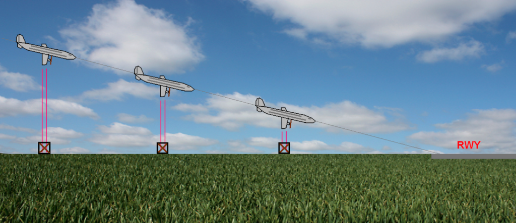
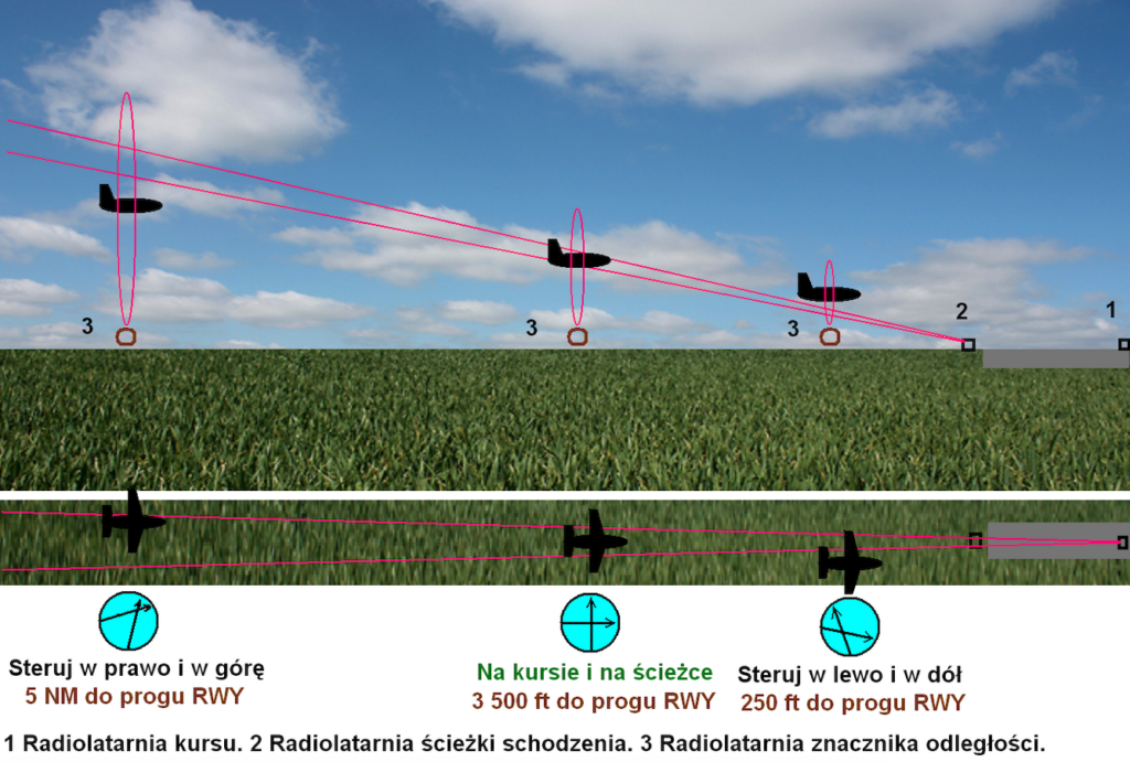
This ILS system, developed over 40 years, should not be identified with the system currently in operation (2013). It was the prototype of the current one and is more similar to the landing system according to the distant and closer radio beacons, used for many decades in the eastern military bloc. It consisted of four radio beacons. The first was a regular en-route radio beacon. After passing it, the crew of the aircraft knew the exact distance to the RWY (DS, runway) and could start descending with the appropriate approach angle (speed of descent). Before the RWY itself, every 1 NM, there were three radio beacons. The aircraft had an indicator with two needles. One horizontal needle – indicated the altitude. When it deflected too much upwards, the aircraft was too low. If too much downwards, the aircraft was already too high. The second vertical needle – indicated the deviation from the correct course. Additionally, there was a signal consisting of three indicators (lamps). Over the years and with experience gained, the radio beacons on the approach to landing were set at different distances. The first one about 5 NM, the second 2/3 NM and 0.1 NM. Of course, a lot depended on the terrain possibilities. Since these systems were expensive to purchase, install and operate, they were not used on all approaches and all RWYs.
Due to the use of radio navigation systems, the role of the compass decreased significantly, although to this day (2013) it has not disappeared from the dashboard. The compass played a greater role in military aviation than in commercial aviation. We will mention the compass and the problems associated with it later. The remaining indicators on board the aircraft were more traditional. Among them, it is worth mentioning; artificial horizon, altimeter, airspeed indicator, variometer. All of these systems were duplicated and sometimes even tripled. The instruments were mechanical or electro-mechanical. The amount of information was obtained from pitot probes. The basis of most of these instruments was the gyroscopic system.
During the period in question, the composition of the crew on board the aircraft was established. The basic crew consisted of three people; two pilots and an on-board mechanic. Sometimes, when a flight was performed on a new route, a navigator joined the crew. Already at that time, procedures were in common use: pre-takeoff, takeoff, flight, landing, aircraft end of operation and emergency procedures. Each procedure was based on a so-called checklist. The aircraft crews were recruited mainly from pilots who had gained aviation experience during World War II. Therefore, they were very experienced crews. In addition, the so-called cabin crew was to serve passengers. Their number depended on the number of passengers on board and the standard of service provided by a given airline. The cabin crew always consisted of women, because women always knew how to create a pleasant atmosphere on board.
Air travel.
Convair, Douglas and Lockheed were three companies that together built over 3,000 passenger planes between 1945 and 1960. These planes determined the general character of commercial aviation in the US and around the world. They provided a high level of safety and comfort. Tickets were expensive, but more and more people decided to travel by plane, which had the advantage over buses, cars or trains that it was much faster over long distances. Passengers were provided with comfortable seats, meals, newspapers and magazines, the possibility of smoking tobacco products and access to toilets. Over time, passengers had the opportunity to listen to music or watch movies. A large percentage of planes, especially in the second half of the 40s, offered night flights in sleeping cabins equipped with couchettes (berths, bunks). Passengers were given the opportunity to take a large amount of luggage on board.
Let’s not forget that in the 40s and 50s the basis of commercial transport was not passenger transport, but postal transport. Letters and parcels were the basic goods that commercial planes took on board.
Written by Karol Placha Hetman

