Stargard 2011-01-20
Byłe lotnisko w Kluczewo.
Współrzędne geograficzne: 53.284N 14.974E. Elewacja 36 m nad poziomem morza.
Infrastruktura lotniska.
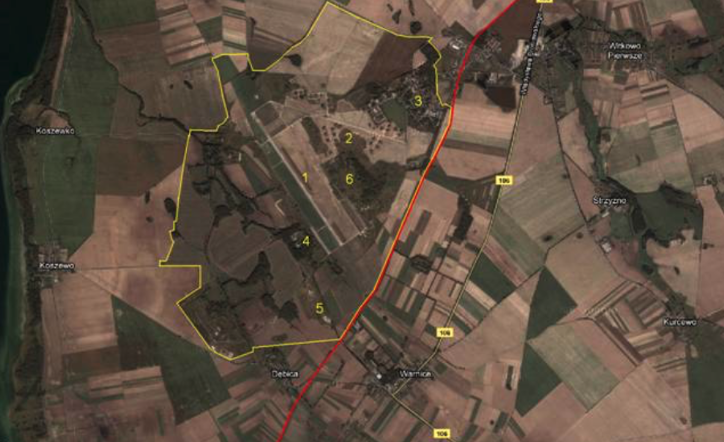
Opis zdjęcia: 1 Główna RWY z drogą kołowania. 2 Droga kołowania będąca także RWY. Obok schron-hangary. 3 Osiedle mieszkaniowe. 4 Baza jednostki łączności i zabezpieczenia radiotechnicznego. 5 Główny skład paliw i smarów. 6 Wieża kontroli lotów i domek pilota.
Lotnisko Kluczewo ma, ale chyba poprawniej będzie, napisać – miało, współrzędne geograficzne; szerokość 53 stopnie 16 minut 50 sekund N, długość 14 stopni 58 minut 00 sekund E. Wysokość 36 m nad poziomem morza. Zlokalizowane było na południowy-zachód od Stargardu Szczecińskiego.
Lotnisko leży przy linii kolejowej Nr 411 Stargard Szczeciński – Pyrzyce. Około 10 km od centrum miasta Stargard, choć do samego Kluczewa jest 6 km. W pobliżu przebiega Droga Wojewódzka Nr 106 (poprzednio 144), łącząca Stargard Szczeciński z Pyrzycami. Główny dojazd do bazy, od strony północnej, zapewnia ulica Lotników, a następnie ulica Czesława Tańskiego lub Generała Leopolda Okulickiego. Do bazy dochodzą dwie bocznice kolejowe. Cały teren ogrodzony był betonowymi słupkami i rozciągniętymi między nimi drutami kolczastymi.
Powierzchnia bazy to około 1 200 hektarów, z czego na samo lotnisko przypadało 609 hektarów. Na ponad 400 hektarach zlokalizowany jest obszar z zabudowaniami. Podstawową budowlą na lotnisku jest oczywiście DS (RWY), o wymiarach 2 515 m x 60 m usytuowana na kierunku 15/33, o nawierzchni betonowej.
Odnośnie RWY w Kluczewie to musimy napisać jeszcze kilka zdań. Początkowo RWY miała wymiary 1 800 m x 40 m i była etapami poszerzana i wydłużana. W 60-latach przystąpiono do przebudowy RWY, nie tylko powiększoną ją do wymiarów 2 515 m x 60 m (kierunek 15/33), ale także zwiększono jej nośność. Dzięki temu z lotniska mogły teraz korzystać także ciężkie samoloty transportowe. W dostępnych informacjach nie ma jednak mowy o wydłużeniu DS do 3 500 m, aby mogła przyjmować strategiczna samoloty bombowe. Jeśli tak to znaczy, że rosjanie w Kluczewie ograniczyli się tylko do lotnictwa taktycznego. Także należy pamiętać, że na lotnisku stale była utrzymywana awaryjna DS, o wymiarach 2 000 m x 100 m o nawierzchni gruntowej (trawa), równoległa do głównej DS. W dostępnych informacjach o lotnisku często jest podawana jako DS jedna z głównych DK. Jej wymiary to 2 229 m x 20 m, usytuowana na kierunku 11/29. Podejrzewam także, że na początku 40-tych lat w planach armii niemieckiej była jeszcze trzecia DS, o kierunku około 6/24.
Kiedy wydłużano główną DS, zawsze czyniono to w kierunku jeziora, na północny-zachód. Z jej zachodniej strony umieszczono równoległą, główną DK, o długości około 2 200 m, która na obu końcach ma PPS. Główna DK z DS jest połączona czterema DK. PPS Nr 1 ma wymiary około 500 m x 50 m i powierzchnię ponad 26 000 m kwadratowych.
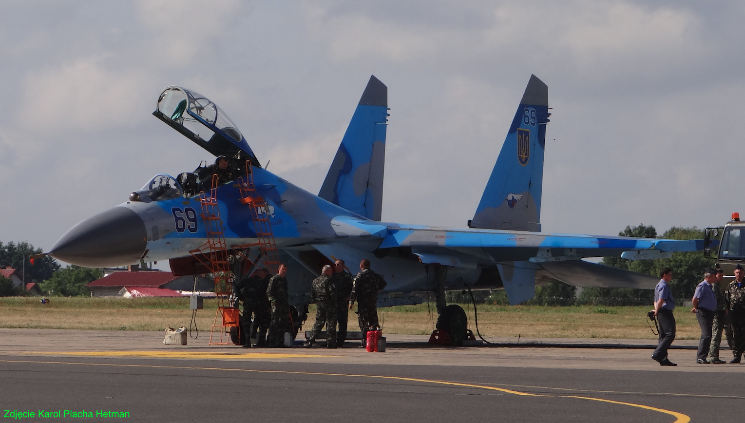
Wzdłuż DK umieszczono kilkanaście indywidualnych stanowisk postojowych samolotów. Niektóre z nich mają nawierzchnie betonową, a inne gruntową i są otoczone z trzech stron wałami ziemnymi. Znajdują się tutaj także dwa schronohangary typu wz AU-11. Ta DK kończy się PPS Nr 2 o wymiarach 100 m x 50 m i powierzchni 5 000 m kwadratowych. Opisany wyżej fragment lotniska jest jego najstarsza częścią. To tutaj stacjonowały myśliwce MiG-15 i MiG-17. Na lotnisku jest droga kołowania, a wzdłuż niej umieszczone indywidualne stanowiska postoju samolotów. Są też wały ziemne oraz schronohangary wzór AU-11, dla myśliwców typu MiG-21. Wrota metalowe mają grubość około 0,30 m. Do budowy schrono-hangarów przystąpiono w drugiej połowie 60-lat. Ich budowa była związana z doświadczeniami wojny w Wietnamie. PPS Nr 2 miała powierzchnię około 5 000 m kwadratowych.
Przemieszczając się na wschód od DS (RWY), mamy kolejną główną DK, równoległą do DS, o długości 2 500 m. Na jej południowym krańcu umieszczono 4 schronohangary typu wzór AU-16, które pełnią obecnie funkcje magazynów. W nieco rozsuniętych wrotach wstawiono bardziej klasyczne bramy. Schronohangary AU-16 mieściły samoloty Su-27.
Schrono-hangary przy PPS Nr 3 zaadoptowane zostały jako magazyny. W pobliżu znajduje się największa PPS Nr 3 o wymiarach około 600 m x 90 m i powierzchni 54 000 m kwadratowych. Płaszczyzna ta została zaadoptowana do obsługi myśliwców Su-27. Miała mieć dystrybutory paliwa przy każdym stanowisku postojowym. Za PPS Nr 3 zlokalizowano 6 schrono-hangarów typu wzór AU-11.
Przemieszczając się dalej wzdłuż DK spotykamy kolejną grupę 9 schrono-hangarów wzór AU-11, w których bazowały MiG-21.
Kiedy skierujemy się na drugi koniec opisywanej DK dotrzemy do PPS Nr 4, która ma kształt trójkąta i pełniła rolę heliportu, czyli miejsca w którym lądowały i startowały śmigłowce, nie kolidując z kołującymi samolotami. Powstała ona poprzez zabetonowanie powierzchni pomiędzy stanowiskami postojowymi, czyli stojankami. W tym miejscu swój początek bierze także trzecia główna DK, która jak wspomnieliśmy mogła pełnić rolę drugiej DS.
Trzecia główna DK, która mogła pełnić rolę DS Nr 2 ma wymiary 2 229 m x 20 m. Ale jej podstawowe zadanie to kołowanie samolotów do licznych schrono-hangarów. W kompleksie tym umieszczono łącznie 36 schrono-hangarów; 23 dla Su-27 i 13 dla innych samolotów. Łącznie na terenie lotniska zlokalizowano 47 schrono-hangarów. Z pośród nich 27 było typu wzór AU-16, a pozostałe wzór AU-11.
Do schronów możemy doliczyć jeszcze 3 schrony typu Granit przeznaczone dla pocisków klasy z-z. Najważniejszym schronem był dwukondygnacyjny podziemny schron dowodzenia dywizją. Były także liczne mniejsze schrony o różnym przeznaczeniu. Oceniamy, że na terenie bazy było około 60 różnego rodzaju schronów.
Na lotnisku znajduje się ponad 8 000 m DK, których powierzchnia wynosi około 150 000 m kwadratowych. Jeśli zliczyć wszystkie DK, wszystkie PPS i powierzchnię DS to otrzymamy 414 900 m kwadratowych betonowych powierzchni dla samolotów.
Z punktu widzenie lotniczego, ważnym obiektem jest wieża kontroli lotów. Wieża jest obiektem, którego budynek powstał za czasów germańskich. W trakcie eksploatacji przez wojska sowieckie wymianie ulegało tylko wyposażenie.
Na lotnisku znajdują się także; skład materiałów pędnych z siecią rozprowadzającą, park samochodowy, obiekty oddziału wojsk rakietowych, centrum dowodzenia, budynki koszarowo – administracyjne, wiele magazynów, kotłownie, osiedle mieszkaniowe, sieć dróg lokalnych utwardzanych (zwykle betonowych), dwie bocznice kolejowe i wiele innych. Na terenie jest około 300 budynków i budowli.
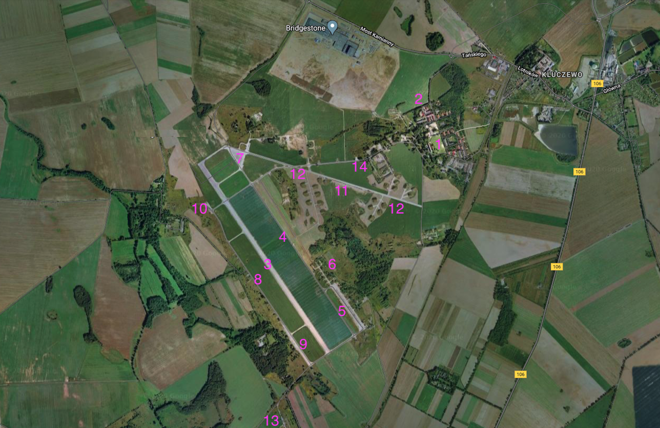
Powierzchnia bazy to było około 1 200 hektarów, z czego na samo lotnisko przypadało 609 hektarów. Na ponad 400 hektarach zlokalizowano obszary z budowlami. We wschodniej części bazy zlokalizowano osiedle mieszkaniowe z kilkunastoma blokami (1). W centrum osiedla jest boisko sportowe. Na terenie osiedla są także budynki szkolne (2).Podstawową budowlą na lotnisku był RWY (3), o wymiarach 2 515 m x 60 m, która była usytuowana na kierunku 15/33, o nawierzchni betonowej. Kiedy wydłużano główną RWY, zawsze czyniono to w kierunku jeziora, na północny-zachód. Z jej wschodniej strony umieszczono równoległą, drogę kołowania (4), o długości około 2 500 m, która na obu końcach ma PPS. Główna droga kołowania z RWY była połączona czterema łącznikami. PPS Nr 1 (5) ma wymiary około 600 m x 90 m i powierzchnię ponad 54 000 m kwadratowych. Płaszczyzna ta została zaadoptowana do obsługi myśliwców Su-27. Miała mieć dystrybutory paliwa przy każdym stanowisku postojowym. W pobliżu PPS Nr 1 znajduje się domek pilota z wieżą kontroli lotów (6).
Wzdłuż drogi kołowania umieszczono kilkanaście indywidualnych stanowisk postojowych samolotów. Niektóre z nich mają nawierzchnie betonową, a inne gruntową i są otoczone z trzech stron wałami ziemnymi. Znajdują się tutaj także dwa schronohangary typu wzór AU-11. Ta droga kołowania kończy się PPS Nr 2 (7) o kształcie trójkątnym, o wymiarach 200 m x 100 m i powierzchni 10 000 m kwadratowych. Opisany wyżej fragment lotniska jest jego najstarsza częścią. To tutaj stacjonowały myśliwce MiG-15 i MiG-17. Schrono-hangary wzór AU-11 mają wrota metalowe grubość około 0,30 m. Do budowy schrono-hangarów przystąpiono w drugiej połowie 60-tych lat. Ich budowa była związana z doświadczeniami wojny w Wietnamie.
W 70-latach zbudowano drugą drogę kołowania po zachodniej stronie RWY (8). Droga miała długość około 2 200 m. Na jej końcach umieszczono dwie kolejne PPS. PPS Nr 3 (9) miała wymiary 400 m x 40 m. PPS Nr 4 (10) miała wymiary 150 m x 40 m. Zachodnia droga kołowania została połączona z RWY czterema łącznikami.
Odnośnie RWY w Kluczewie to musimy napisać jeszcze kilka zdań. Początkowo RWY miała wymiary 1 800 m x 40 m i była etapami poszerzana i wydłużana. W 60-latach przystąpiono do przebudowy RWY, nie tylko powiększoną ją do wymiarów 2 515 m x 60 m (kierunek 15/33), ale także zwiększono jej nośność. Dzięki temu z lotniska mogły teraz korzystać także ciężkie samoloty transportowe. W dostępnych informacjach nie ma jednak mowy o wydłużeniu RWY do 3 500 m, aby mogła przyjmować strategiczne samoloty bombowe. Jeśli tak, to znaczy, że sowieci w Kluczewie ograniczyli się tylko do lotnictwa taktycznego. Także należy pamiętać, że na lotnisku stale była utrzymywana awaryjna RWY, o wymiarach 2 000 m x 100 m o nawierzchni gruntowej (trawa), równoległa do głównej RWY. W dostępnych informacjach o lotnisku często jest podawana jako RWY jedna z głównych dróg kołowania. Jej wymiary to 2 229 m x 20 m, usytuowana na kierunku 11/29. Podejrzewamy także, że na początku 40-lat w planach armii niemieckiej była jeszcze trzecia RWY, na kierunku około 6/24, czego nie wykonano.
Na lotnisku jest kolejna droga kołowania, która w sytuacjach alarmowych wykorzystywano jako RWY (11). Droga miała wymiary 2 500 m x 25 m. Przy tej drodze zorganizowano trzy strefy rozśrodkowania ze schrono-hangarami wzór AU-16, które były głównie przeznaczone dla samolotów Su-27 (12). Strefa w stronie północnej nie została ukończono. Na lotnisku było ponad 8 000 m dróg kołowania, których powierzchnia wynosiła około 150 000 m kwadratowych. Jeśli zliczyć wszystkie DK, wszystkie PPS i powierzchnię RWY to otrzymamy 414 900 m kwadratowych betonowych powierzchni dla samolotów.
Na lotnisku był także MPS (skład paliw) (13), park samochodowy (14), magazyn uzbrojenia (bombo-skład), posterunki radiolokacyjne i łączności, obiekty jednostki rakietowej, wiele magazynów, kotłownie i inne.
Teren byłego lotniska został przeznaczony na strefę przemysłowa. Zbudowano tutaj kilka zakładów produkcyjnych i magazynów firmowych.
Opracował Karol Placha Hetman