Mińsk Mazowiecki 2024-01-10
Mińsk Mazowiecki railway station.
Geographic coordinates: 52.175N 21.552E. Elevation 151 m.
Minsk Mazowiecki.
Mińsk Mazowiecki is a city located in the Masovian Voivodeship in Poland. Mińsk Mazowiecki has a rich history and is known for its cultural heritage. The city has historical monuments, including churches, and serves as an administrative and cultural center for the surrounding areas. The distance between Mińsk Mazowiecki and Warsaw is approximately 42 kilometers. This is a relatively short route, which makes traveling between the two cities quite quick, both by car and public transport. Currently, the city's population is 40,297 (in 2022), and the city's area is 13.18 square kilometers.
The railway reached Mińsk Mazowiecki in the 19th century. The first railway line in this region was opened on October 9, 1866 and connected Warsaw with Terespol. Mińsk Mazowiecki was one of the stops on this route, which significantly influenced the development of the city and facilitated the transport of passengers and goods. The railway was an important factor in the economic and communication development of many towns in Poland at that time.
Mińsk Mazowiecki railway station.
The station was opened on October 9, 1866. Currently, Mińsk Mazowiecki is a category B station. It is the starting and ending station for many Koleje Mazowieckie EMU trains. Within the station there are ZNTK Mińsk Mazowiecki SA.
The first station at Mińsk Mazowiecki station was brick, but small. The second station has already been built as a representative station. It was characterized by a multi-body shape and a decorative cornice. This station was destroyed during World War II.
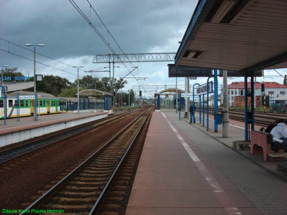
The current station was built in 1979 and is modernist, spacious and functional. The building has large glazing, thanks to which the interior is bright. The main hall serves as a waiting room. There are ticket offices, toilets, ticket machines and more in the building.
In the period 1998-2000, the station was modernized. The platforms were raised, the platform edges received prefabricated red slabs with a yellow safety line. A new underground passage was built on the eastern side of the platforms for passengers and residents. The crossing is adapted for people in wheelchairs and parents with strollers. The crossing was put into operation on June 2, 2007.
The footbridge over the tracks was renovated, which also serves residents as it connects the northern and southern parts of the city. There was also another footbridge over the tracks, which was demolished in 2006 due to its poor technical condition and the construction of a new underpass. There was also a level crossing for wheelchair users, but it was removed. This passage was not connected to the southern part of the city. There are traffic lights at the station.
Currently (2024) there are three platforms at the station. Platform 1 has one edge and is located next to the station building. It is 200 m long and accepts agglomeration trains. Platforms 2 and 3 are island platforms and are 270 m long. There are bus shelters on the platforms. The plans provide for the construction of Platform 4 at track No. 9, as a single-edge platform, 200 m long, 5.00 m wide and 0.76 m high. The planned order completion date was August 6, 2024.
To the east of the railway station is the freight section of the station used for unloading aggregates and general cargo. There is a loading yard from Spółdzielcza Street. The station has 8 main tracks on railway line No. 2, as well as numerous side tracks, mainly to ZNTK, which is located in the southwestern part of the station. ZNTK "Mińsk Mazowiecki" is a company belonging to the PESA group. It repairs and modernizes electric rail vehicles, such as EMU EN57. In recent years, its clients included the most important railway carriers in Poland: PKP Intercity, Polregio, Koleje Mazowieckie.
In 2021, the station served 2,850,000 passengers, i.e. 7,808 people per day. In January 2024, 105 passenger trains departed from the station. You could go to: Białystok, Czeremcha, Gdynia Główna, Grodzisk Mazowiecki, Lublin Główny, Łowicz Główny, Łódź Fabryczna, Łuków, Mrozy, Siedlce, Skierniewice, Terespol, Warszawa Centralna, Warszawa Wschodnia, Warszawa Zachodnia, Żyrardów.
Warsaw-Terespolska Railway.
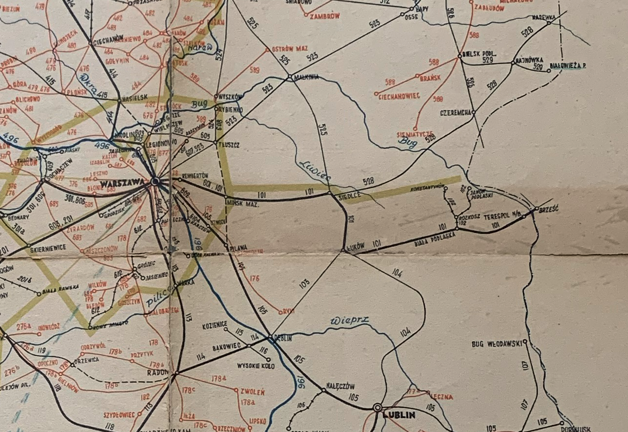
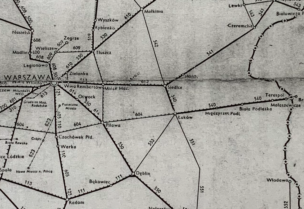
The Warsaw-Terespol Railway was established as the third railway line in the then Kingdom of Poland, i.e. under the Moscow partition. The line was launched on October 9, 1866. The line connected the stations Warsaw - Mińsk Mazowiecki - Siedlce - Łuków - Terespol. In Terespol, the line connected with the Moscow-Brest Railway. In 1873, another Brest-Kiev route was opened.
The Warsaw-Terespol Railway was built with a wide track, in accordance with Moscow standards. In Warsaw, Praga, this route was connected with the Saint Petersburg Railway by a railway siding. The Terespolski Railway Station in Warsaw was located at Brzeska Street (now Kijowska Street). This station was renamed Dworzec Brzeski, and now it is the Warszawa Wschodnia station.
The Warsaw - Terespol route was built in the period 1865–1867 by the Warsaw-Terespol Railway Company. The initiator of the venture was the entrepreneur and banker Leopold Kronenberg. The line was 212 km long. Construction works were completed on September 27, 1866. The organizational structure and administration were modeled on the Warsaw-Vienna Railway. The employees were also of Polish nationality. Some of the employees came from "Wiedenka". Engineer Chrzanowski became the director.
Due to the lack of a railway bridge over the Vistula River, passengers from the Terespolski station had to use horse-drawn carriages to reach the Warsaw-Vienna Railway. It was a big obstacle, but it contributed to the development of Warsaw. Every traveler from the Muscovite state going to the West (Vienna, Wrocław, Berlin, Paris) had to be in Warsaw. Only in 1876, the Circuit Railway was built, which used the new railway bridge over the Vistula and connected the "Wiedenka" with the other two routes. For this reason, the Muscovites ordered the "Wiedenka" to be converted to a wide track. The Circular Railway was launched in 1876, connecting the railway routes of Warsaw's Praga with Warsaw and enabling rail transport. Although reloading between different track gauges was necessary.
In 1891, the Warsaw-Terespol Railway was taken over by the Moscow state. In 1896, the Warsaw-Terespol Railway was merged with the Vistula Railway into Koleje Nadwiślańskie. During the Great World War, the Germans converted all wide tracks to standard gauge. After Poland regained independence, the management of the line was taken over by the Polish State Railways. The current route of the Warszawa Zachodnia - Terespol line largely coincides with the line of the Warsaw-Terespol Railway. In 1933, a cross-city line was opened in Warsaw, which connected the Terespolski Railway Station (now Warszawa Wschodnia) with the newly built Main Railway Station (destroyed during World War II).
Railway line No. 2.
Railway line No. 2 Warszawa Zachodnia - Terespol is 214.227 km long. The line is a standard-gauge, double-track, electrified 3 kV DC traction network. The maximum speed on the trail is 160 km/h. This speed applies to approximately 80% of the line length (Warsaw - Biała Podlaska). Currently (2023), design work is underway to increase the speed of trains on the Biała Podlaska - State Border section, i.e. up to 160 km/h for passenger trains. The line is a fragment of the international line E20, which is part of the 2nd Pan-European West-East Transport Corridor connecting Berlin - Moscow.
Electrification; In 1937, the Warsaw - Mińsk Mazowiecki section was electrified, i.e. before the Germans and Muscovites attacked Poland. Two English companies took part in electrification. Agreements with them were subject to special clauses that required the employment of Polish specialists and workers, as well as the use of traction network elements produced in Poland. The beginning of electric train traffic dates back to December 15, 1937.
However, the stupid Germans started another war and lost more territories. After World War II, electrification started again in the second half of the 50s. On line No. 2, in 1975, electrification was introduced to the Mrozy station. On December 22, 1977, electric trains arrived in Łuków, and on December 20, 1979, in Biała Podlaska. Electric trains entered Terespol on December 15, 1980.
Due to the great importance of line No. 2, the line is constantly modernized. The goal was to achieve a running speed of 160 km/h for passenger trains and 120 km/h for freight trains. The track load was also increased to 221 kN per axle.
In the period 1998-2000, the Warszawa Rembertów - Mińsk Mazowiecki section was rebuilt. The investment cost is EUR 19.5 million. In 2000, the modernization of the Mińsk Mazowiecki - Siedlce section began and was completed in 2003. As part of the project, the Mrozy and Siedlce stations were modernized. Automatic crossing signals were installed on the line. New passenger stops were built. The entire line is equipped with an automatic linear lock. A new railway traffic control system has been introduced. A Local Control Center was built at the Mińsk Mazowiecki station, which manages traffic on the Warszawa Rembertów - Siedlce section. On the Mińsk Mazowiecki - Siedlce section, 62 UOZ-1 devices to deter animals were installed.
In 2006, modernization of the line on the Siedlce - Terespol section, 121 km long, began. The work was divided into several stages. The track system and electrical network were modernized, platforms and engineering structures on the route were rebuilt. On this section, the first trains with a speed of 160 km/h started in 2010. Since 2017, work has been underway to modernize the last section of the trail to the state border.
Railway line No. 2: Warszawa Centralna, 0 km. Warsaw East, 4.25 km. Warszawa Podskarbińska, 5.98 km. Warszawa Antoninów, 7.71 km. Warszawa Rembertów, 11.57 km. Warszawa Wesoła, 16.38 km. Warsaw Wola Grzybowska, 18.18 km. Sulejówek, 19.98 km. Sulejówek Miłosna, 21.56 km. Józefin, 24.35 km. Halinów, 25.66 km. Cisie, 28.81 km. Dębe Wielkie, 31.35 km. Nowe Dębe Wielkie, 32.66 km. Wrzosów, 35.80 km. Mińsk Mazowiecki, 40.56 km. Mińsk Mazowiecki, 43.08 km. Barczaca, 46.14 km. Mienia, 50.42 km. Cegłów, 53.78 km. Mrozy, 58.68 km. Grodziszcze Mazowieckie, 63.79 km. Sosnowe, 68.76 km. Koszewnica, 72.17 km. Kotuń, 77.90 km. Sabinka, 85.37 km. West Siedlce, 89.86 km. Siedlce, 92.69 km. Siedlce East, 95.30 km. Doły, 96.72 km. Białka Siedleckie, 97.30 km. Kosiorki, 100.33 km. Borki Kosy, 102.85 km. Dziewule, 107.32 km. Radomyśl, 109.87 km. Krynka Łukowska, 112.67 km. Łuków, 120.44 km. Łuków Zapowiednik, 122.50 km. Matysy, 128.07 km. Szaniawy, 131.55 km. Brzozowica, 136.06 km. Misie, 141.67 km. Międzyrzec Podlaski, 148.65 km. Sitno, 154.24 km. Chess, 157.40 km. Sokule, 160.48 km. Porosiuki, 167.99 km. Biała Podlaska, 172.86 km. Biała Podlaska Eastern, 174.99 km. Ogrodniki, 180.82 km. Perkowice, 183.63 km. Chotyłów, 188.89 km. Dobrynka, 194.80 km. Magdalenka, 197.83 km. Małaszewicze Południowe, 199.92 km. Małaszewicze Stop, 201.59 km. Kobylany, 203.94 km. Terespol, 209.28 km. State border, 211.65 km.
Railway line No. 522 Mińsk Mazowiecki R45 – Mińsk Mazowiecki R102.
Railway line No. 522 is a connecting line from the Mińsk Mazowiecki station, single-track, electrified (December 22, 1970), 2,205 km long. The line connects the railway line No. 13 Krusze - Pilawa, which is 56.604 km long and runs longitudinally. The maximum speed on the slip road is 40 km/h.
Written by Karol Placha Hetman