Warszawa 2019-01-24
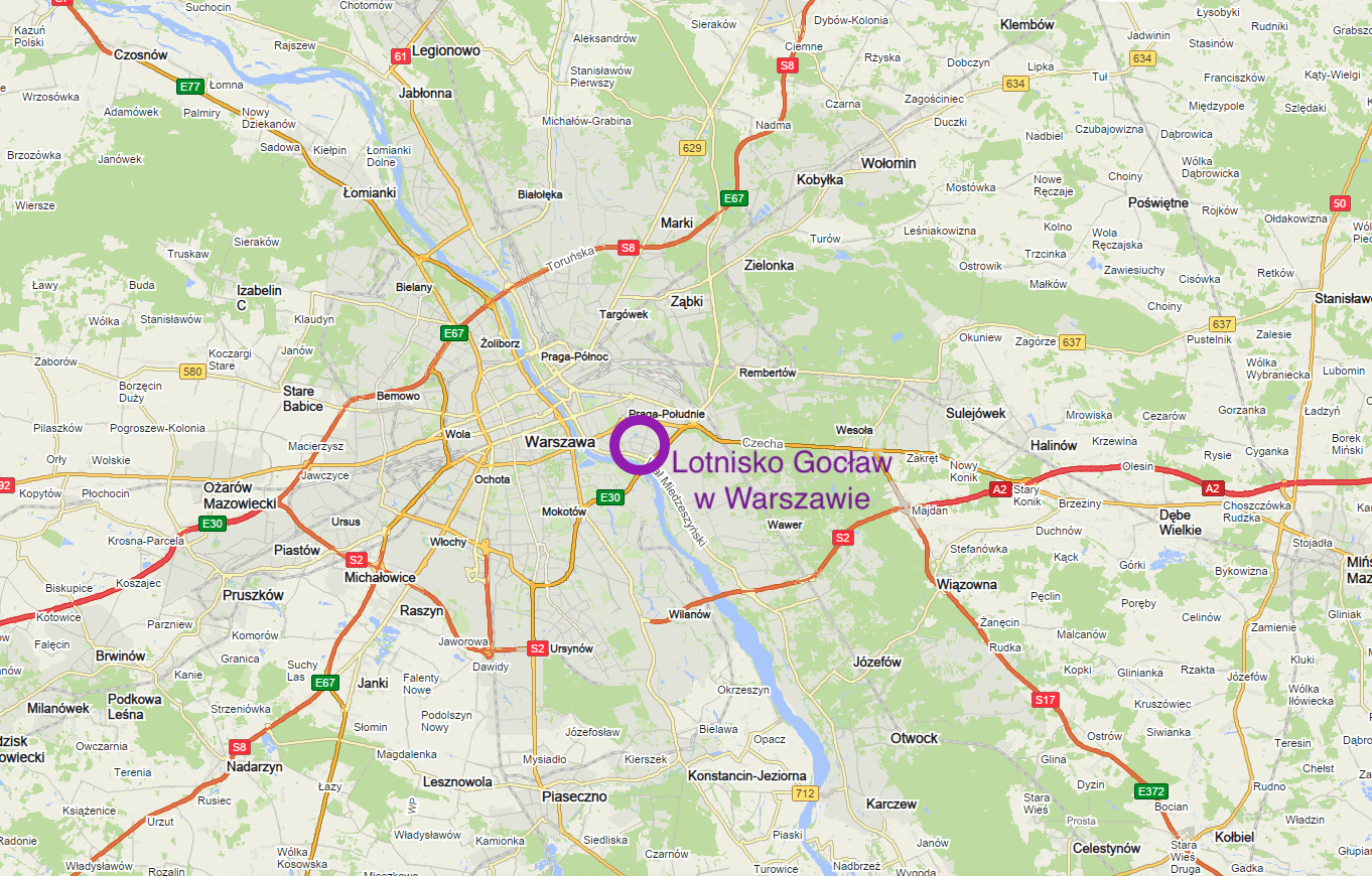
Goclaw - Warsaw Airport.
Geographic coordinates: 52.225N 21.092E.
Mokotowskie Airport, better known as Pole Mokotowskie, and in 1930, it began to be too small. At that time, it was decided that two new airports would be built. One military airport in Okęcie and the second communication airport in Gocław.
A long time ago, Gocław was called Gościsław or Gościsława. The name probably comes from the name of the owner or his wife. Historical documents state that from the 12th century Gocław belonged to the Płock Bishopric. Gocław, as a village, was a small settlement. There were only a few houses here. The terrain was swampy and wet. Here and there were clumps of lush bushes. The area was often flooded by the spring thaws of the widely spreading Vistula, which often changed its main stream. The area was not suitable for farming, and the inhabitants worked mainly with animal husbandry and weaving various items from wicker and reed. In the 18th century, the estate became royal property. After the third partition of Poland, the property became the property of the state treasury, i.e. the occupier. At the beginning of the 20th century, the village had only 25 homesteads with wooden houses and about 400 inhabitants. During the Great World War (April 1916), Gocław, Grochów and Saska Kępa were administratively annexed to Warsaw.
In 1933, the first plans to build a sports and recreation airport were made, with the assumption of moving it from Pole Mokotowskie. Nothing came of it then.
The choice of Grochów as a new communication (commercial) airport for Warsaw was very logical. Exactly, the airport was to be located in the area of the so-called Kępa Gocławska, i.e. the area between the village of Gocław and the Vistula River. The village of Gocław would remain intact. It is worth remembering that in the 30s there were no comprehensive land development plans. Nevertheless, fertile fields were not converted for purposes other than plant cultivation.
The airport would be located near the planned bridges on the Vistula river: railway and road, as well as the river port. In the future, it would be an important transhipment hub. The railway bridge was to be part of the southern railway bypass of the capital. It was to be used primarily by freight trains, which in this way would bypass the "Średnicowa" route. A street of local importance was to be built along the railway tracks. The road bridge was to be placed on the extension of United States Avenue.
The aforementioned river port was initially called Solec due to the salt warehouse run here. During the Second Polish Republic, the port was known as the port of Saska Kępa. Over 20 years, about PLN 4 million was spent on its expansion. Mainly agricultural products were transshipped in the port on the routes from Kraków, Sandomierz, Warsaw, Bydgoszcz (Bydgoski Canal) and Gdańsk (duty-free zone). Barges were mainly handled here. The port lost its importance after the expansion of other ports in Warsaw: the Praski port and the Żerański port. After World War II, the port of Saska Kępa was better known as the port of Czerniakowski.
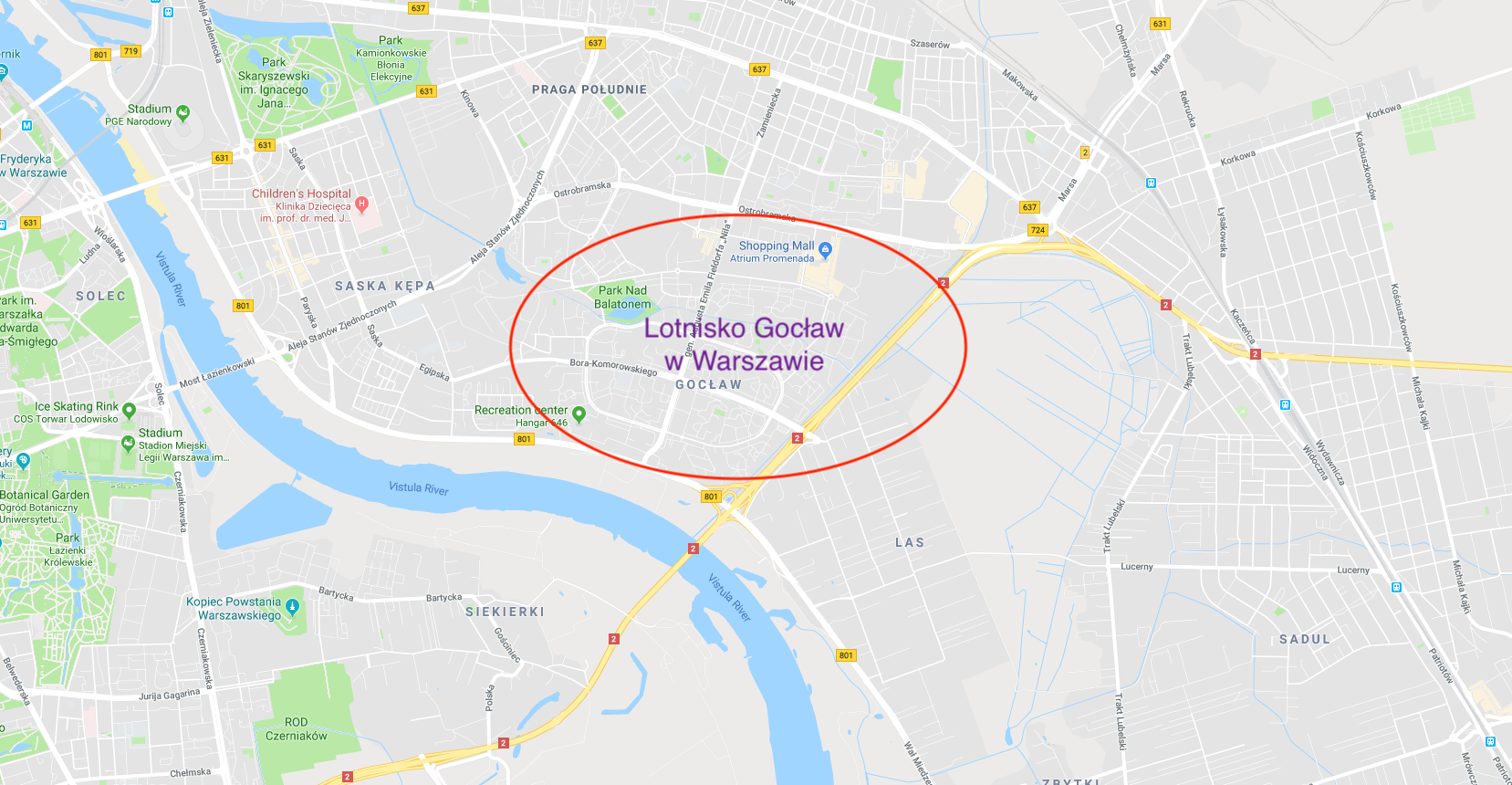
The area of Gocław was not considered by the city councilors of Warsaw as factory or, even more so, residential areas. The ground was low and very wet. The areas of present-day Saska Kępa and Praga Południe were planned for construction. However, the terrain had a big advantage in the form of an elevation amplitude, which is only 79 to 88 m above sea level. The land slopes gently to the south-east. From the side of the Vistula River, the flood embankment had to be improved, which at that time was not yet completed.
The area, being wet, was drained. In this area of Warsaw and beyond, in the so-called Wawerska Lowland, there are several non-navigable meliorative canals. They were created at different times. The most famous is the Wawerski Canal. During the preparations for the construction of the Gocław Airport, the Gocławski Canal (2,320 m long) and the Nowa Ulga Canal (5,600 m long) were renovated, and a pumping station was built on the latter. From the Gocławski Canal there is a branch on which an artificial reservoir has been created, which has no official name and is unofficially called Lake Balaton. The lake has an area of 2.64 ha and is connected to the Gocław Canal by two connecting channels.
The Gocław airport was to receive a typical ellipse-shaped take-off field. At that time, a circular or elliptical landing field was standard. The shorter axis of the ellipse is more or less a straight line drawn from the mouth of the Nowa Ulga Canal to the intersection of Ostrobramska and Generała Emila Fieldorfa Nila Streets (north-south direction). The longer axis is the east-west direction. The axes intersected in the area of Władysława Umińskiego and Złota Wilga streets. The water channels in the landing field were to be hidden in a pipeline.
Several paved runways were marked out on the take-off field, which were to be used mainly by larger and heavier aircraft. This hardening resulted more from the waterlogged terrain than from later technology. The paved runways were to have an asterisk layout so that, regardless of the wind blowing, there was always a road located (approximately) in the wind axis.
The first sketches of future objects were made in 1938. The executive documentation was to be created at the turn of 1939/1940.
The airport was to be built on Ivy. (Currently, the area of the junction of Trasa Siekierkowska, Wał Miedzeszyński and ul. Jugosłowiańska). International Street was to lead to the airport itself.
The station was to have two levels. One of the plans envisaged it as a three-storey building, because on the roof there was to be a parking lot and stops for public transport: buses, taxis and horse-drawn carriages. On the main level there were to be: cash registers, waiting rooms, shops, restaurants, toilets, and a post office. On the lower floor there was to be: check-in for departing and arriving passengers, a radio station, a telephone exchange, a meteorological facility, and social facilities for flying personnel. The station was to serve a minimum of 300 passengers per day.
A little to the east of the station, terraced hangars for various airlines with full facilities were to be built. Each of the hangars was to have a minimum size of 30 m x 40 m and a minimum height of 10 m. They were to be used for the ongoing maintenance and repair of aircraft. Already then, the focus was on servicing metal aircraft: Douglas DC-2, Douglas DC-3, Lockheed L-14 Super Electra, PZL-44 Wicher.
At the airport it was planned to mount; beacon, goniometer, light beacon, lighting for night flights. A fuel and lubricant depot was to be built, but its location was not determined. There were plans to build a tram line to the airport station.
Until the invasion of the Germanic plague on the Republic of Poland, Poland managed to level the area of the field of ascents. The network of drainage canals was expanded and a pumping station was built in Bluszcze. This pumping station is still in operation (2019) and is located among the streets of the road junction: Droga Wojewódzka No. 801 (Wał Miedzeszyński Street) and A2 Motorways (Generała Bolesława Wieniawy-Długoszowskiego Avenue).
In September 1939, the landing field was bombed. The Germans dropped their bombs mainly on the part of the landing field on the eastern side of the New Relief Canal. During the Second World War, the airport was not used.
In 1945, the idea of building a communication airport was resumed. We managed to repair the western part of the launch pad to the New Relief Channel. In 1946, on the repaired part of the landing field, a sports airfield was established, which was used by the Warsaw Aeroclub.
Ambitious plans to build a communication airport were systematically thwarted by the new communist authorities. For the communists, the airport in Gocław was unnecessary. They built a new airport in Bemowo, which was launched in 1949. In 1950, the obliging communists openly criticized the idea of building a communication airport in Gocław. It was reported that it was too close to the center of Warsaw. Just 6 km. It was also raised that the planned runways were too short for the new aircraft.
It is worth mentioning that the route to the Łazienkowska route planned by the communists coincides with the road to the Gocław airport planned in 30 years. The planned railroad bridge and southern railroad were abandoned.
At the beginning of the 50s, two large hangars with facilities were built at the airport. They were to serve the future airport. Throughout the period of operation of the airport, these hangars were used by the Warsaw Aeroclub and medical aviation. Currently, they are the only remnant of the airport and stand at Wał Miedzeszyński Street. The first hangar (on the west side) has an area of 2,700 square meters at the base and a height of 15 meters. Since 2015, the "Trampoline Park" entertainment center has been located here. The second hangar (on the eastern side) has an area of 2,000 square meters at the base and a height of 12 meters. The hangars are made of brick, and the roofs of the steel structure are covered with a wooden roof and roofing felt.
The take-off field of Gocław Airport had a ground (grass) surface all the time. Concrete planes were only around the hangars. In 1970, the Gocław airport had an area of 225 hectares.
According to the communists, the Aeroclub airport in Gocław was very burdensome for the inhabitants due to the large number of small planes and gliders in the air. (?!) Interestingly, the Aeroclub was moved to the Bemowo-Babice airport, also in the vicinity of residential estates.
The Gocław airport functioned as an aeroclub until 1976, when it was closed and its landing field was intended for the construction of housing estates for the expanding Warsaw. Already in 1972, the competition for the urban plan of the new housing estate was settled. In 1977, the Workers' Housing Cooperative "Osiedle Młodych" started building the largest housing complex on the right bank of the Vistula, Gocław-Airport. The first apartments were occupied in 1979.
The former landing field of the Gocław Airport has been crossed by Bieruta Street, now Generała Bora Komorowskiego (from east to west) and Zawadzkiego Street, now Generała Augusta Fieldorfa Nil (from north to south). The whole was surrounded by Jóźwiaka Street, and currently there are four streets: Generała Romana Abrahama, Władysława Umińskiego, Jugosłowiańska and Janusza Meissnera. The following housing estates were placed in the resulting quarters: Orlik, Wilga, Jantar and Iskra. All names come from Polish aircraft. Gocław also includes the Kępa Grochowska and Przyczółek Grochowski housing estates. Gocław is one of the largest blocks of flats in Warsaw. The existing housing resources include approximately 13,000 flats and 300 commercial premises. Currently (2019) Gocław is inhabited by about 55,000 inhabitants. The boundaries of the Gocław area are Ostrobramska Street, Tysiąclecia Avenue, the Vistula River and the Nowa Ulga Canal. It is an area of 410 hectares.
In today's reality, the area of 410 hectares is definitely not enough for a large communication airport. If there were Gocław Airport here, the areas of the Las and Sadul estates would certainly be attached to it. And all this so that at least one runway is 2,500 - 3,000 m long.
Written by Karol Placha Hetman